Map and census records of individual brickworks (diagram still being built)
A Whiteparish local history page from younsmere-frustfield.org.uk
This page is still under construction - more material to be added
This page is being created to serve as an introduction to the separate pages on the various village brickworks. Further details on each can be found as follows, with only the blue links being available on the public version of this website:
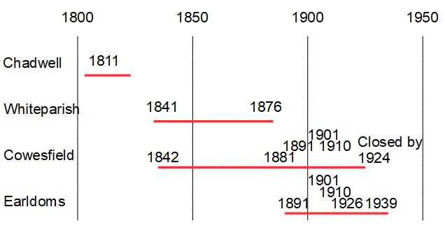
Map evidence is by its nature intermittent, but gives a starting point for understanding the number of brickworks in Whiteparish at any one time. The tentative conclusion is that brick making moved from Chadwell to Whiteparish and then on to Cowesfield. Earldoms appears to have started up shortly after Cowesfield and the two then ran in parallel until after 1926, probably up until 1939 or 1940 when Scotch Kilns were banned during the war. This was because they were unroofed and the glow could be seen from the air during the period of days the kiln needed to be kept fired. The owners were considering reopening the Earldoms Brickworks in the 1950s, but although they bought more suitable land in preparation, it didn't happen [ref: personal communication].
Map and census records of individual brickworks (diagram still being built)
The earliest recorded brick kiln was at Chadwell Farm on the 1811 map, the only brickworks shown at that date.
The 1841 census doesn't give occupation for very many people, but the list does include two brothers who responded Brick M (presumably brick maker) and two responding Brick Burner. The 1842 Tithe Map provides clarification, listing parcel 1254 as The Brickkiln (this is Whiteparish Brickkiln) and marking "Brick Kiln" alongside the pits and buildings of Cowesfield Brickkiln, parcel 1310 opposite where the brickyard stood being simply labelled as "buildings and yards".
The 1881 1:10,560 OS map records Whiteparish Brick Field and Cowesfield Brickkiln. This is reinforced by the 1876 1:2500 map showing Whiteparish and the 1896 map at the same scale showing Cowesfield. Chadwell is no longer shown, and Earldoms still woodlands.
Not until the 1891 1:2500 map is Earldoms Brick Works shown, and Cowesfield Brickkiln is still there, and both are shown on the 1901 and 1910 maps. Earldoms is also shown on the 1926 map (revised 1924), but on this map Cowesfield is shown as Old Kilns. Cowesfield is still shown as Old Kilns in 1962. Earldoms has Clay Pit marked on that map, but the business on that site had changed to Mills by then (known from personal sources to have been sawmills).
On 16th September 2021 Jamie Wright gave a talk to the Whiteparish History Group on the Fisherton and Bemerton Brickworks. In it he mentioned that he had found a will that described the stock held by Cowesfield Brickworks and he related how Cowesfield roof tiles were used in one stage of the building of Fisherton Anger Gaol (see Cowesfield Brickworks for more detail and the building phases of Fisherton Anger Gaol). Jamie is also the author of a book on the Fisherton and Bemerton Brickworks.