This page is under development with further research to be added
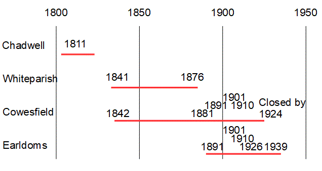
The brick kiln at Chadwell only features on one early map, the 1 inch to a mile Ordnance Survey first edition, which was surveyed in 1811. The next map showing the site is the 1842 Tithe Map, which labels two fields as Kiln Yard and Kiln Mead. By that date the brick field at Whiteparish was operating, and the four people associated with brick making in the 1841 census almost certainly worked there.
Chadwell Farm had been given for the poor of Downton parish by William Stockman in 1626 and in 1811 was still used to support charity work in Downton. In 1842 it was listed as owned by the Downton Free School foundation.
Based on this limited information, the probability seems to be that Chadwell Brick Kiln dates from the early 19th century and that it had closed after at most perhaps 20 or 30 years of operation, when the Whiteparish Brickfield started operation in the years running up to 1842.
Map and census records of individual brickworks

No brickworks shown on the 1773 map
 .
. 
Chadwell Brick Kiln on the 1811 OS 1 inch map, close up and wider views
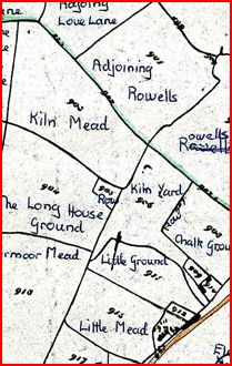
The same area in 1842 on the Tithe map, with the fields Kiln Yard and Kiln Mead noting the previous presence of a kiln
 occupiers.jpg)
Occupiers in 1844, showing the land granted to the parish of Downton by William Stockman in 1626, recorded as owned by Downton Free Schools in 1842
Kiln Yard and Kiln Mead are to the right of the red area marked