Not all links on this page work on the public version of this website. 'Alt+Left arrow' will return you to the page you left from a missing link. Please ask if you'd like particular links to be uploaded more quickly.
Introduction
The roads through Whiteparish that we now know as the A36 and A27 became turnpikes late in the eighteenth century, with the Sarum and Eling turnpike in operation along the route of the A36 through Whiteparish from 1753 to 1870 and the Whiteparish Romsey and Southampton turnpike along the A27 from 1756 to 1878. There were two turnpike houses and gates in Whiteparish on the Romsey turnpike, one of them on the main carriageway at the junction of Doves Lane and Pill Hill with The Street, and a side gate on Common Road in what is now the garden of 8 Croft Heights. There appears to have been one on the Eling turnpike at Earldoms [being researched]. Folk history has added various assumed gates that don't feature in the turnpike records and certainly didn't exist. A notable one is Cowesfield Gate, which was simply one of many gates across the road, in that case dividing the manors of Cowesfield Spilman to the west and the detached part of Alderstone to the east. Speculation on the presence of a gate at the Hatchet Inn in Sherfield English is likewise not supported by the extensive turnpike records that still exist today.
In broad terms, the Romsey turnpike ran along what is now the A27 from Brickworth Corner in Whiteparish to Romsey and then the A3057 from Romsey to Southampton, finishing at the Bargate. Changes were made to a number of sections of the road over its 122 year life, with some parts replaced with new road and others moved to use other pre-existing roads. The positions of gates changed too, with some turnpike gates moved, new ones added and old ones removed. The records also throw light on road works and diversions for widening, resurfacing, improvement of drainage and sundry other alterations that are clearly not just modern inconveniences.
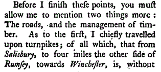
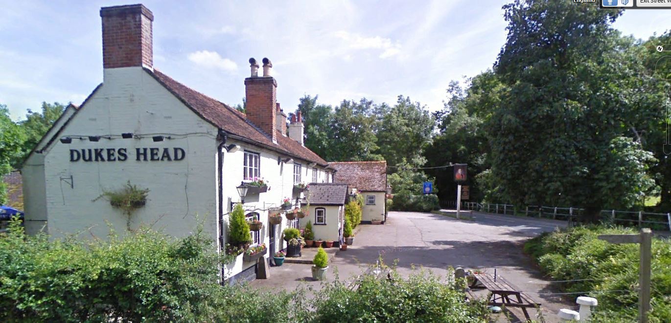
The section of road from Whiteparish to Romsey was part of the route taken by Arthur Young in 1768. Writing about his travels through the southern counties of England and Wales, he described the road between Salisbury and four miles north of Romsey in glowing terms as the best quality road he had ever seen, "having more the appearance of an elegant gravel walk, than of an high-road." The Whiteparish, Romsey and Southampton turnpike had been there for 12 years at that time. This part of his route included sections of other turnpikes from Salisbury to Whiteparish and north of the Duke's Head in Romsey; perhaps they shared the same subcontractors or sources of materials.
This page currently contains a comprehensive account of the Whiteparish, Romsey and Southampton turnpike. Research into further detail continues, and similar details for the Sarum and Eling turnpike will be added here in due course.
Contents of this page
What is a turnpike?
Turnpike trusts were bodies set up by individual acts of Parliament which collected tolls from users to maintain the principal roads in Britain from the 17th but especially during the 18th and 19th centuries. At the peak, in the 1830s, over 1,000 trusts administered around 30,000 miles (48,000 km) of turnpike road in England and Wales, taking tolls at almost 8,000 toll-gates and side-bars [see Wikipedia Turnpike Trust]. It is often not appreciated today that individual turnpikes had relatively few toll gates, for example the roughly 17 miles of the Whiteparish Romsey and Southampton turnpike appears initially to have had only six toll gates, with two more added later, and at least two of these gates were on joining roads rather than across the main carriageway. This is very different from modern toll roads with gates on all entrances and exits, and which can't be used at all without paying a toll.
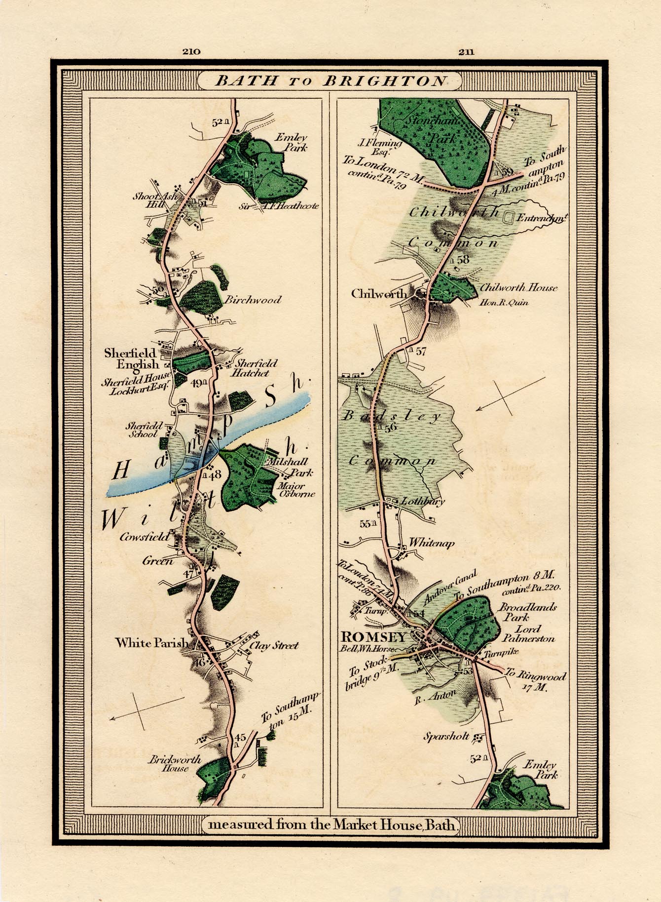
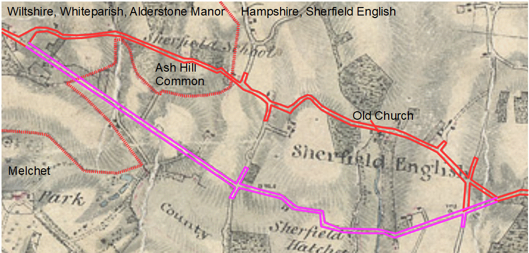
The Route of the Whiteparish-Romsey-Southampton Turnpike


Left:The route of the Whiteparish Romsey and Southampton turnpike, showing earlier and later routes from Dunwood to Romsey, south of Romsey, and in Southampton
9 known gate positions are shown, not all present at the same time
Right: the two turnpikes through Whiteparish; Blue: Whiteparish, Romsey and Southampton, Red: Sarum and Eling
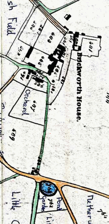
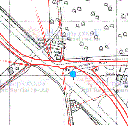
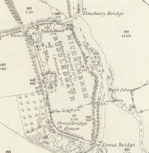
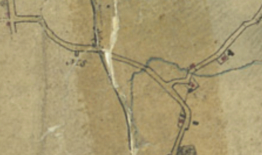
The Whiteparish-Romsey-Southampton turnpike opened in 1756 and ran until 1878. It was 20 miles long, initially with 6 main gates, one of which stood on the south side of the A27 at the junction with Doves Lane and Pill Hill. Pembroke House now stands on the site, next door to the Gatehouse. There was a side gate on Common Road at 8 Croft Heights. The road started at Brickworth Corner at a pond in the Brickworth House garden that was only filled in when the road junction alignment was changed in the early 1960s [find precise date, still a pond in 1924, not in 1966] , branching there from the Sarum and Eling Turnpike, which had opened three years earlier along the line now taken by the A36. The junction at Brickworth Corner in 1842 shown on the left hand map below was still almost identical in 1901, but has changed significantly since; the right hand map below shows the earlier layout superimposed on a modern map, although further changes have since been made to add the entrance to the Brickworth Sand Quarry. See Brickworth estate and scroll down from there for more detail of the development of the Brickworth Corner junction (planned to be moved to Brickworth Corner).
 .
.  .
. 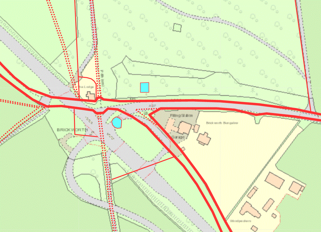
Left: Brickworth Corner in 1842; Right: the alignment of the roads and A27/A36 junction in 1901 overlaid on a 1966 map and overlaid on a 2023 map
The Sarum and Eling turnpike crosses each map from left to lower right, the upper road on the right in each case being the Whiteparish Romsey and Southampton turnpike
The Whiteparish, Romsey and Southampton turnpike had the particular distinction of having been singled out by Arthur Young in his 'Six weeks tour through the southern counties of England and Wales', written in 1768 some twelve years after its opening. In glowing terms he described this road as by far the best he had travelled on, going on to describe some of the worst as well.
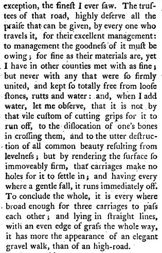
Arthur Young's description of the turnpike from Salisbury to Romsey
From A six weeks tour through the southern counties of England and Wales, Second Edition 1769
Written in 1768 [1st edition?], 12 years after the turpike started
Mogg 1814 strip map from Whiteparish to Romsey oldhampshiremapped
Whiteparish at bottom of left hand strip, to Romsey near the bottom of the right hand strip, by the later route, now the A27
Whiteparish Section
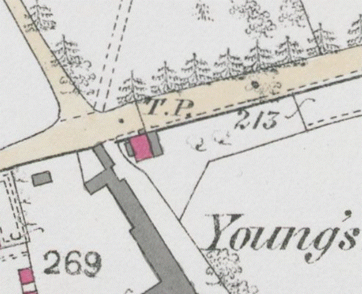
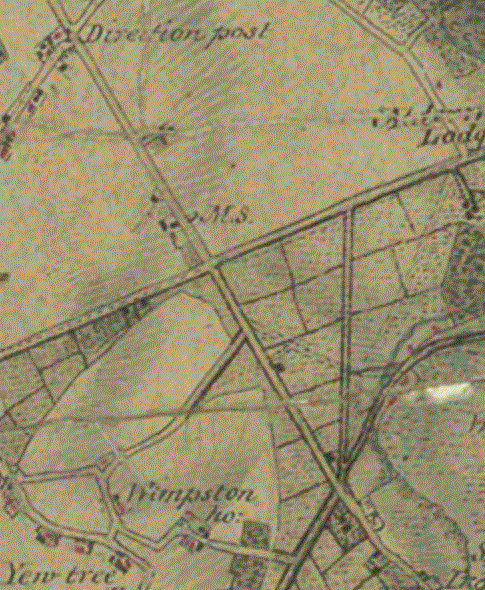
From Brickworth Corner the Whiteparish Romsey and Southampton Turnpike ran into Whiteparish along the route now taken by the A27 to its first toll gate, in The Street next to the junction with Doves Lane and Pill Hill, near Lascar Electronics. The toll house stood on the corner of Doves Lane and The Street next to Young's Farm, now the garden of Pembroke House, with the garden extending the full widths of the front gardens of Pembroke House and The Gatehouse.
 .
. 
Left: The turnpike gate on The Street in 1876
Right: A tracing of the turnpike house, gate and garden from the left hand map overlaid on a 2023 map
There was a side gate on Common Road in what is now the garden of number 8 Croft Heights. On the 1876 below. Whiteparish Brickworks is to the right of Rosebank and the turnpike gate. [With many small boundary changes between 1876 and 2023, alignment is quite challenging, so has been deduced from a wider area than is shown including the church and school house. The alignment of Rosebank is a consequence, suggesting that this is the same building as in 1876 and if so confirming correct positioning - see drawing.]
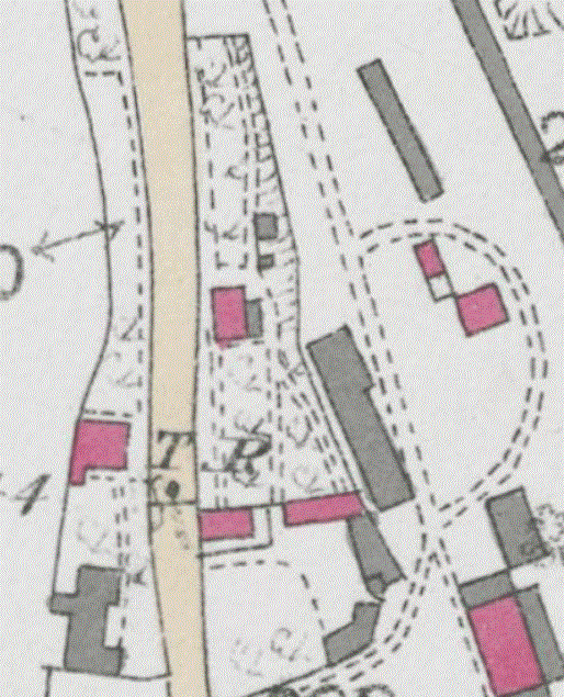

Left: The turnpike gate on Common Road 1876
Right: The gate and key other features traced from the 1876 map and overlaid on a 2023 map
These two gates in Whiteparish appear to have existed through the whole 122 year life of the turnpike road, in contrast to several of the other gates that were more temporary and were moved, added or removed from time to time as the extension and development of Romsey and Southampton took place.
Whiteparish to Sherfield English
From Whiteparish the route passed through Cowesfield and then along a specially constructed new section of road to Sherfield English. The old road to Sherfield English had left the A27 by the Morrisholt Farm track at the east end of Cowesfield Wood, crossed Bunny Lane and passed Ash Hill House, carrying on to Sandy Close Farm at the north end of Graemar Lane that runs north from the old Sherfield English Post Office. From there it followed Church Lane past the old Sherfield church and Manor Farm, down Pound Hill to cross Branches Lane close to the A27 and join the existing route just east of the junction. The name Sherfield Hatchet shown on the map below was introduced by the Post Office, to the considerable annoyance of the local population, as evidenced by this newspaper article of the time. The name was dropped in due course.

Ash Hill Common in 1879
The new road followed, and still follows, a straight line from the Morrisholt Farm track on the A27 to the cross roads with Graemar Lane and Steplake Lane. I've often wondered whether the road initially followed the lay of the land over the series of hills and dips here, or was levelled as it is now. It then followed a more winding route onwards past the new (present) Sherfield English church, The Hatchett inn, and past Glebe Farm to rejoin the old route just past the Newtown junction.

The old and new roads from Cowesfield to Sherfield English with annotations on the right hand map
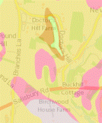
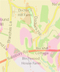
John Hartley, sherfieldenglish.org.uk/history writes that "The road would have needed a huge quantity of both chalk and gravel because it passed across several low-lying boggy areas. This aggregate would have been excavated from as close to the road as possible, and undoubtedly one of the main sources in Sherfield English was the valley running down Doctors Hill, which is within a few hundred yards of the road. This excavation was on such a large scale that the entire valley now cuts right through all the sand, gravel and clay layers to the underlying chalk, with the consequence that there is no longer any surface water flowing from the springs around its head - the water disappears immediately into the porous chalk floor of the valley." On the map below the excavated area is represented by an area of the Lambeth Group sand (pale brown), cut through by an area of Lambeth Group clay, silt and sand (darker brown), with a smaller area of Culver Chalk (green) within that.
.gif)
.gif)
The excavated area on Doctor's Hill referred to by John Hartley, showing chalk in green (right hand image shows the background map more clearly)
Maps from BGS showing bedrock geology at 1:50,000 scale
Dunwood and Shootash
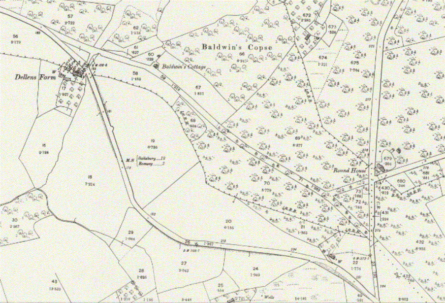
Half a mile further on, where the road now bends right at Dunwood Manor, the original route ran straight ahead up the hill to join what is now the west end of Old Salisbury Lane. The right bend through Shootash and continuation to Green Hill and Mainstone now taken by the A27 here was a later upgrade to the turnpike. Papers of 1835 to 1851 describe the construction of a new road at Dunwood Hill on the Whiteparish, Romsey and Southampton turnpike road and the sale, by the turnpike trustees, of the old roads at Dunwood to Peter Barfoot. Coming from Whiteparish, the A27 takes a right bend at Dellens Farm to continue towards Green Hill. The earlier road had continued straight ahead at this point to cross Danes Road close to the western end of Old Salisbury Lane, about half way between the present Old Salisbury Lane and A27 junctions on Danes Road.
The line of the old road at Dunwood Hill, Shootash, is still followed by a public footpath from Dellens Farm to Danes Road. It crossed Danes Road roughly half way between the present Old Salibury Lane and A27 junctions. Old Salisbury Lane continued for a short distance on the west side of Danes Road to join it, a section still very visible through the gate opposite the end of Old Salisbury Lane.

The old spur road at the west end of Old Salisbury Lane where it crossed Danes Road, looking west from the current junction
It is believed [confirm in turnpike records] that the route of the turnpike was changed at that date (1835-1851) from using Old Salisbury Lane to the present A27 route to Mainstone. [4M92/V5/4/8 dated 1835-1851, 4M92/V5/5/6 dated 1863-1866, taking land previously owned by Lord Palmerston.]
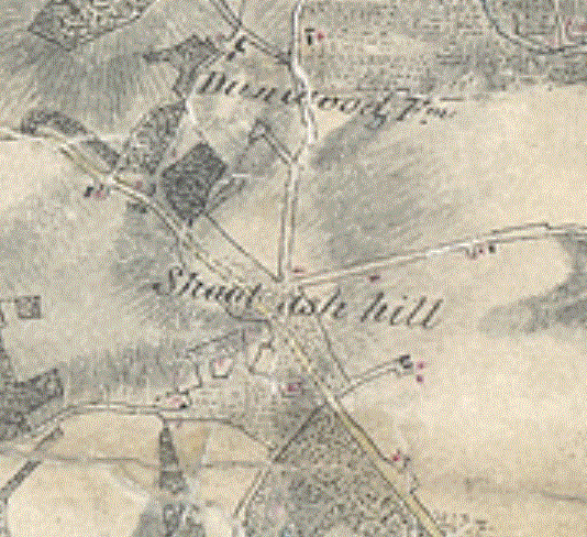
Left: Shootash in 1807 on the drawing for the first edition Ordnance Survey maps, showing the old roads
Right: 1845 Romsey Tithe Map showing the new road, but with the line of the old road and Old Salisbury Lane spur still visible
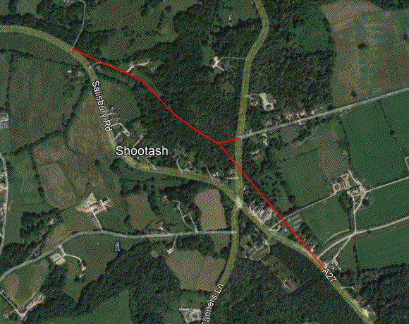
The line of the old roads at Dunwood Hill, Shootash, before the new turnpike section was constructed
Old Salisbury Lane (Greatbridge) and Mainstone (Middlebridge) Routes
For the first 80 years, from 1756 until the 1830s the next part of the route followed Old Salisbury Lane to the Duke's Head pub (now Duke on the Test), turning right to pass over Greatbridge and then by way of Greatbridge Road and Cherville Street into Romsey. In the 1830s Green Hill was 'lowered' and the new section of road from Dellens Farm to Shootash described above was built. From that time onwards the route followed the line of the modern A27 down Green Hill to Mainstone, crossed Middlebridge and followed Middlebridge Street and Bell Street into Romsey (the modern bypass was built much later). As mentioned above, the old road joining Dunwood to Old Salisbury Lane was sold off, and a turnpike gate added at Embley, this then being the closest gate to Whiteparish on the revised route. Curiously, I've found no clear evidence for an earlier gate at the Romsey end of the Whiteparish-Romsey section of the road, which I'd expect to have been at the east end of the Salisbury Lane section, even though the Romsey and Winchester turnpike had a gate on Standbridge Lane (B3084) there on the road to Awbridge. This could suggest that the turnpike never followed Old Salisbury Lane in the first place, but on the other hand I've found no evidence for a toll gate at the Romsey end of the Middlebridge route either.
The map below shows the Duke's Head junction, with a turnpike gate at Timsbury Bridge on the Stockbridge turnpike. The 1808 map is indistinct, so it may perhaps show another gate across the road from Romsey. At the next junction west, the Andover turnpike branched north along the B3084, with a turnpike gate at Awbridge, and the Whiteparish turnpike going up Old Salisbury Lane - this might have been the place to expect to see a gate, but I've not been able to find any suggestion that this was so.
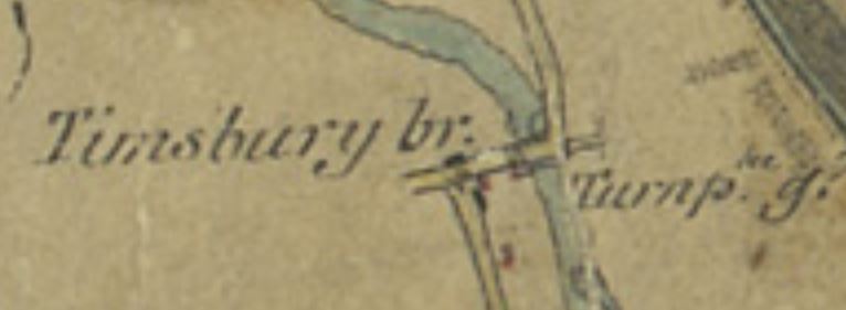
Left: Turnpike gate at the Duke's Head/Timsbury Bridge in 1808 on the drawing for the 1st edition OS maps
Right: The junction on the Romsey Tithe Map 1844
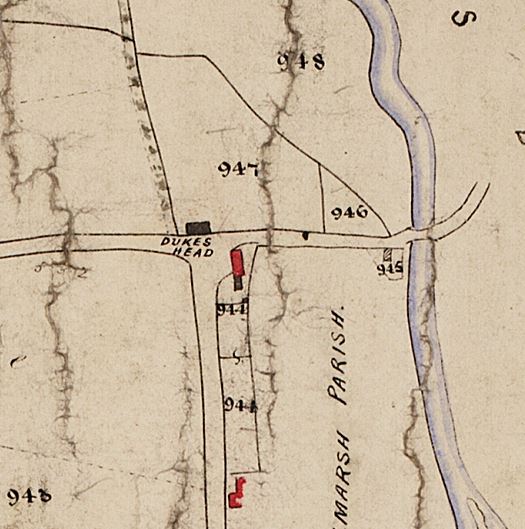
944 Hall Charles John; Coles William; House garden yard and buildings (page 14 in Romsey Tithe Award)
945 Fifield Job & Hall Charles John; Stone Anne; Cottage and garden (page 42)
946 Hall Charles John; Sillence William; Warwick's garden; Garden; (page 15)
947 Hall Charles John; in hand; Warwick Upper Field; Arable; (page 14)
948 Hall Charles John; in hand; Rooks Meadow; Meadow; (page 14)
In March 2006 Bob Goodwin gave a talk to the Whiteparish Local History Group about his research at the Winchester Record Office into Romsey Turnpikes, including part of the Whiteparish, Romsey and Southampton turnpike (see Roads for further detail). Initially, having run the full length of Old Salisbury Lane to the Dukes Head pub, now The Duke on the Test [2023], the turnpike turned right over Greatbridge, a wooden bridge at that time. In the Stockbridge direction the road ran straight ahead to cross the Test behind the Duke's Head pub (now The Duke on the Test), from where it turned left to join the road north of where the present bridge stands. The 1895 map below shows this layout, with the Stockbridge road crossing the Test on the Timsbury Bridge in line with Old Salisbury Lane and the turnpike turning right. The new Timsbury Bridge in its present position was built later than 1908 and before 1944 [ref OS 25 inch maps surveyed in 1908 and 1944], and the rebuilding of Greatbridge in its present form in 1911 may well have coincided with construction of the new Timsbury bridge and consequent modification to the line taken by the Stockbridge road.

The original line of the Romsey-Stockbridge turnpike passed the left side of the Duke's Head (now The Duke on the Test) directly in line with Old Salisbury Lane
Greatbridge itself is also of some interest here. Bob Goodwin's research showed that the Trustees could construct bridges, but if there was a bridge already in existence it became the responsibility of the County to maintain it. We know that Romsey Corporation raised money for repairs to Greatbridge in 1656 and 1688, but that it was then left for 90 years, by which time part of it had fallen down, even though the turnpike had by then been using it for 32 years. When it was rebuilt in 1778, the town had to raise nearly £70 for its share of the work. A likely date for the change of route detailed above, to the present line of the A27 from Shootash to Mainstone, is between 1835 and 1851 when the new section of road was built at Shootash to reduce the slope and height climbed and the lowering of Green Hill took place.
Greatbridge remained as a wooden bridge until it was replaced with the present structure of bricks and metal in 1911, long after the turnpikes stopped operating . The same reference (below) clarifies that Greatbridge had been a problem for many centuries because the boundary between Romsey Infra and Romsey Extra ran along the river through the middle of the bridge, so it was subject to divided ownership and agreement about repairs was difficult. On the south side the owner was Romsey Corporation, who could raise a rate for their share, but the north side lay with private, albeit wealthy, owners. The bridge was eventually adopted by the County Council who were liable for its subsequent upkeep. [ref: Hampshire Chronicle 5th April 2022.]
.gif)
.gif)
1866 (survey date) and 1895 maps showing the alignment of roads at Greatbridge (and modern map for comparison). The central map also shows the bridge across the canal at the top of this section
(The fourth map is the same view as the third, but with OS copyright 2023, so not available on public website)
South from Romsey to Ashfield
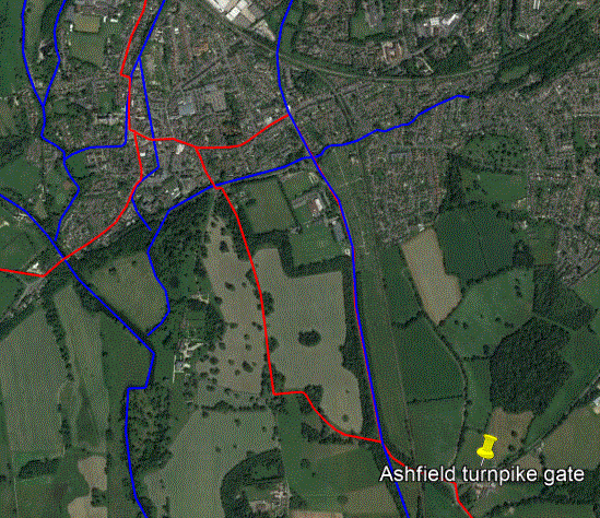
Going south from Romsey, the modern A27 to Ashfield has the boundary wall of the Broadlands estate on the right (west side) and reaches a Broadlands lodge just before the junction with Lee Lane. This was a new road constructed by the turnpike trust a little before the parallel canal went out of use in 1849. This replaced the old main road south from Romsey, which followed Palmerston Street to where the roundabout is now on the bypass, then Burma Road through what is now part of the Broadlands parkland but was at the time the eastern edge of the park. At the south end of the estate the road to Lee ran straight ahead, while the road to Ashfield and Southampton turned left to where the lodge and gateway is now on the A27, then followed the course of the modern road to the Ashfield roundabout and on down the line of the A3057. There was a turnpike gate close by on the road coming from North Baddesley for traffic joining the turnpike from that direction.
.jpg)

Left: The Broadlands Lodge at Ashfield
Before 1849 the main road to Romsey passed through the gates to the left and the canal was just behind where the Broadlands wall stands, parallel to the A27
Right: the pre-1849 (left) and post-1849 (right) main road south from Romsey with Romsey in the background
At that time the Andover canal ran from where it now ends at the Plaza cinema down Southampton Road, then just inside what is now the Broadlands wall and straight on along Lee Lane, and neither of these sections of modern road existed. The new road from the Plaza to Lee Lane, and Lee Lane itself, were built at that time to replace the turnpike road through the estate, building the wall being part of the deal as the canal closed and the railway was built, thus enclosing the old line of the canal just inside the estate, where its remains still run. The Broadlands park was extended at the same time to include the area between the old and new roads. The turnpike gate at Gunville (Gunvil on old maps) next to the roundabout at the east end of the Romsey bypass, where the toll house can still be seen today, dates from the time of this road diversion. (Small) yellow pins marking the old and new Gunville turnpike gates can be seen at the top of the aerial view above.
Left: Sparsholt to Ashfield on the 1809 drawing for the first edition Ordnance Survey map; Right: Ashfield in 1895 (OS 25 inch)


Left: 1809 - The 'Gunvil' gate by the present Broadlands entrance, also showing the gate on Winchester Road and the one at Ashfield
Centre: The Romsey road network in 1830, showing the road south going through what is now Broadlands and the canal where the present A27 runs south
Right: Over a modern view, the 1830 main road through what is now Broadlands, and canal where the A27 and Broadlands wall have since been built

Burma Road was was the main road to Southampton in 1756; the Gunville Turnpike Gate would have been just out of sight in this modern view [right: 1908]
Approximate original position of Gunville Gate on 1844 map, by which time it had moved to its present position
This was at the south end of the later (pre-1908) quarry [possible correction: I suspect it may have been at the north end of the quarry]
[Useful reference: Southampton Local History Forum article on the 1845-6 Town Map of Southampton, see also Sotonopedia article]
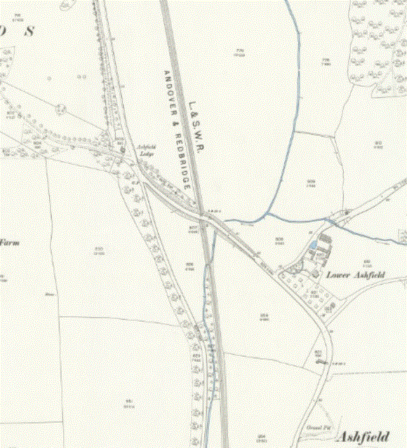
At Ashfield there was a gate on the side road coming from Luzborough, but not on the main carriageway.

Left: The gate at Ashfield on the 1809 [check] OS drawing (on the road on the right, to the right of the stream)
Right: The Turnpike house and gate is 578a on the Romsey Tithe map [date]
Ashfield to Maybush and Brownhills
From Ashfield the route then ran on along the A3057 past gates at Brownhills and Maybush. These two gates were very close together, about half a mile apart, so probably one was on the road and the other controlled traffic joining the turnpike from a side road. Maybush is three miles from the Bargate in Southampton, where the road heads, and initially no gates were permitted closer to the Bargate [at what date?]. This changed when Commercial Road was built by the Turnpike Trust, with a gate added at the Bargate end. The Brownhills and Maybush gates figure in the Hampshire Records Office documents from the 1830s onwards. Neither area has a turnpike gate shown on the 1806 drawing for the 1st edition OS maps, so possibly these gates came later.

Left: Upper and Lower Brownhill Road meet the turnpike road at crossroads at the centre of this 1806 drawing for the OS map
Right: Maybush is around the next junction, where the Ordance Survey head office used to stand (junction of Wimpson Lane and Rownhams Road with A3057 Romsey Road)
These maps overlap - both locations are visible on both maps
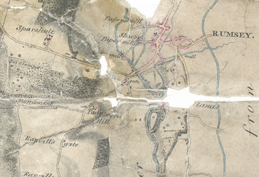
Maybush to Southampton
From Maybush the turpike ran on as far as the coast to join the road along the shore, crossing Rolles Brook by means of Achards Bridge, close to the modern railway footbridge across the east end of the station. There is a watercolour dated c1828 by Thomas Gray Hart that shows Achards Bridge at this spot and the shore towards Southampton. Rolles Brook still runs through the green space to the east of Springhill Catholic Primary School, but then disappears under the station, and Achards Bridge, also known as Four Posts Bridge, crossed the brook on the shore road, Canshut Lane. Canshut Lane led the road to Regent Street, the only western entrance to Southampton at the time.
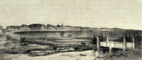

Left: Achards Bridge c1828 in the watercolour 'Western Shore' by Thomas Gray Hart
Right: 'Western Walls' by the same artist, oil on wood
Photo credit: Southampton City Museums
When the turnpike trust was formed, one of the conditions was that there should be no gate closer than three miles from the Bargate, and the position of the Maybush gate respects that restriction. However, a new road, Commercial Road, was later constructed in the 1770s by the Turnpike Trust, joining Havelock Road to Fourposts Hill to join the older Shirley Road turnpike route northwards. A new gate was placed at the east end of Commercial Road, as shown by the 1806 drawing for the 1st edition OS maps below. The turnpike comes in at the left side of the map from Shirley along what is now the A3057, turns right and runs east along Commercial Road to Above Bar Street, and then turns south to reach the Bargate. At the junction of Commercial Road and Above Bar Street are the words 'Turnpike gate'. It is hard to see exactly where this stood, but presumably dates from the construction of Commercial Road as a toll road in the 1770s, as a further improvement to the route. This gate doesn't figure in the Hampshire Records Office documents, but those date generally from the 1850s onwards. By that time it is possible that there were plenty of good roads that allowed users to avoid the Commercial Road gate, rendering the gate uneconomic.
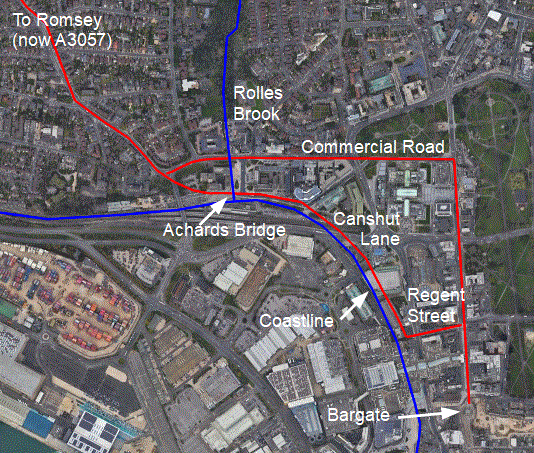
The two routes through Southampton, showing the old coastline
From Sotonopedia: Commercial Road links Above Bar Street with Four Post Hill and the Shirley and Millbrook Roads. It was constructed in the 1770's superseding the traditional Canshut Lane route out of town towards the west, and at the same time separating West Park from the rest of West Marlands. It was originally a toll road.
From Sotonopedia: Canshut Lane was the traditional route out of walled Southampton towards the west. It followed modern Regent Street to the shore and then turned northwards following the western shore to the vicinity of the modern railway footbridge to cross the northern station yard and then to Four Post Hill via Achards Bridge. It remained a major thoroughfare until the construction of Commercial Road in 1791. The name presumably derives from the Hampshire dialect word 'canshutting' for the timber-reinforced embankment along the tidal shore. An alternative name was Windmill Lane, as two windmills stood in or near the road.
From Sotonopedia: Achards Bridge carried Canshut Lane, the only road out of the medieval town towards the west, over the Rolles Brook. It was probably built in the 13th century (it is mentioned in a grant of 1253) but the identity of the eponymous Achard is unknown. In early documents it is referred to as Pons de Arcado and it is shown on a map of 1770 as Pons Achardi. It was also called Acorn Bridge, a corruption of Achard Bridge. Other alternative names were Hill Bridge, from the nearby hamlet and lane, and Four Posts Bridge because it marked the westward limit of the town's liberties and carried four direction vanes.
It seems to have been demolished in the first part of the 19th century. A watercolour of Western Shore by T G Hart c.1828 (image below) shows the bridge, but the Town Map of 1845-46 only marks its former site, which suggests that it was demolished between these dates, possibly to make way for the construction of Blechynden Terrace. The modern-day site of the bridge is in the Southampton Central railway station forecourt, to the north of the main entrance.

Southampton on the 1806 drawing for the 1st edition OS map, showing the turnpike gate at the east end of Commercial Road
Timeline of changes on Whiteparish-Romsey-Southampton Turnpike
| My ref | HRO ref | Date | Details |
| My ref | HRO ref | 1756 | Turnpike established |
| 139 | HRO ref | 1799-1830 | Purchase of Newmans House, Romsey |
| 113 | HRO ref | 1837 | Embley toll gate |
| 137 | HRO ref | 1821-1828 | Taking land at Hatchet Inn to widen road |
| 135 | HRO ref | 1831 | Lowering Spurshott Hill |
| 132 | HRO ref | 1835-1851 | New line of road at Dunwood Hill |
| 113 | V4/3/4 | 1837 | New toll gate at Embley |
| My ref | HRO ref | 1839 | New gates and posts at Gunville |
| My ref | HRO ref | 1850 | New toll house |
| 149 | HRO ref | 1851 | Sale of old road at Dunwood |
| My ref | HRO ref | 1852-1869 | Gates recorded at Ashfield, Brownhill, Embley, Gunville, Maybush, Whiteparish |
| 128 | HRO ref | 1860 | Road diversions |
| 129 | HRO ref | 1860 | Widening Fox Bridge |
| 133 | HRO ref | 1863-1866 | Stop up old road, new road across land owned by Lord Palmerston [Dunwood/Dunhill] |
| 130 | HRO ref | 1864 | New bridge at Old Shirley |
| 123 | HRO ref | 1867 | Sewer from Shirley Lane to Fourposts |
| 124 | HRO ref | 1876 | Tramway from Shirley to Southampton |
| 117 | HRO ref | 1878 | Sale of toll houses (8 items) |
| My ref | HRO ref | Date | Details |
| My ref | HRO ref | 1878 | Turnpike closed |