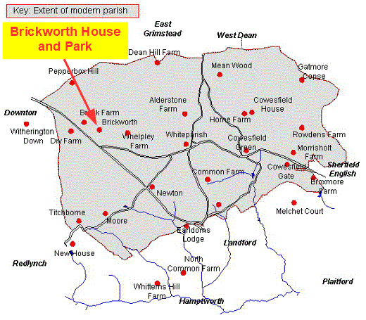
A Whiteparish local history page from younsmere-frustfield.org.uk
From Wiltshire Notes and Queries, Sept 1905 (also see A history of Landford, which mentions this Wiltshire Notes and Queries article). [Reconsider the Abbotstone boundary with Whelpley] The Brickworth estate which formed part of the tithing of Abbotstone, was conveyed on 15th May 1605 to Giles Eyre, then of Redlynch, by Richard Plott of Wantage, Berks and John Lamb of Coulston Wilts for the sum of £950 and in 1628, William, the brother of Giles, granted him “all his lands in Brickworth”. The Eyre family was connected with this tithing as far back as Edward II’s reign when we find in the Nomina Villarum a Thomas le Eyre mentioned as one of the three proprietors in this tithing of Abbotstone. .
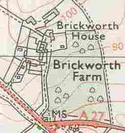
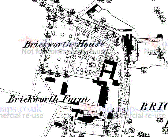
Brickworth House and Park occupy the eastern part of Whelpley Manor, west of the A36 and north of the A27 at their junction. The house is within an earlier hamlet in Whelpley Manor that was known as Breck or Breckore that can be traced from early in the fourteenth century. For this earlier history see Brickworth Hamlet.
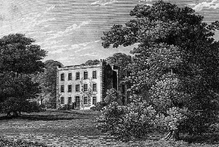

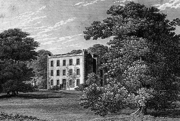
Brickworth House engraving in Matcham before page 34, published by J.B. Nichols & Son, November 1844
There is an enlarged view of the house below and click here for a larger full image
The right hand picture is a well executed pencil copy of the engraving from the book shown at left, taken from my photograph "Broxmore House030.jpg". This is presumably a page from the WI scrapbook and includes the photograph of Broxmore House used on that page and some typed text dated November 1970.
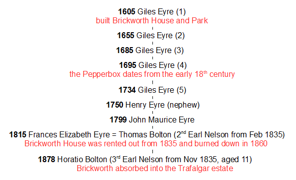
After its establishment in 1605 the Brickworth estate was owned and occupied by the Eyre family until 1835, starting with five successive generations with the same name: Giles Eyre (sometimes spelt Gyles). Having the same name has caused some confusion already in past recording of the history of this estate, so for clarity the generations are identified below by adding the generation number in brackets. From 1835 the house was rented out until it was destroyed by fire in 1860. The Eyre family continued to own the estate, but from 1878, when the dowager Countess Nelson Frances Elizabeth died, Brickworth became part of the larger Nelson estate owned by her son Horatio Nelson (born Horatio Bolton) as third Earl Nelson. Brickworth Park is still there today alongside the A27, one of its lodges standing at the junction with the A36 and the iconic Pepperbox on Pepperbox Hill nearby.
Brickworth photographed in November 1947 (Historic England) and 2020 (Google)
The drive from the lodge to the A27/A36 junction leaves through the trees at the top, left of centre
The first Giles Eyre, Giles Eyre (1) purchased land in this part of Whelpley in 1605 and is assumed to have constructed Brickworth House and Park. It is also mistakenly held that he built the Pepperbox, even though this building dates from 100 years later in the early eighteenth century. While it clearly wasn't built by this Giles Eyre (1), it was built by a Giles Eyre: from the date of the building it must have been erected by Giles Eyre (4) or (5), as discussed below.
The descendants of Giles Eyre (1) were to continue buying extra land to add to the estate, notably in 1615 and 1657, so that by the time of the 1842 Tithe Map the Eyre estate in Whiteparish amounted to 1355.7 acres, or some 21% of Whiteparish.
The Brickworth estate passed through the five Giles Eyres, father, son, grandson, great grandson and great great grandson all having the same name, then to Henry Eyre, the son of Giles Eyre's (5) brother John. Henry's son John Maurice succeeded him and then John Maurice's daughter Frances Elizabeth. When Frances Elizabeth Eyre's husband Thomas Bolton became the second Earl Nelson, he took the name Nelson and they moved to Trafalgar House and Park. Their son Horatio Bolton became the third Earl Nelson on the death of his father in 1835, aged 11, but didn't inherit the Brickworth estate until the death of his mother 43 years later in 1878. Brickworth House, meanwhile, was rented out until it burnt down in 1860.
Owners of Brickworth Park
Our earliest view of Brickworth Park comes from the Andrews and Drury map of 1773, which clearly shows the park boundary. There were three entrances, the southern one next to the A27/A36 junction and two entrances from Pepperbox Hill on the northwest boundary. The northernmost ran directly to the house while the southern one served the farm. The pond that stood immediately in front of the (garage) car wash at Brickworth Corner is shown as an extension to the park on the south side of what is now the A36.
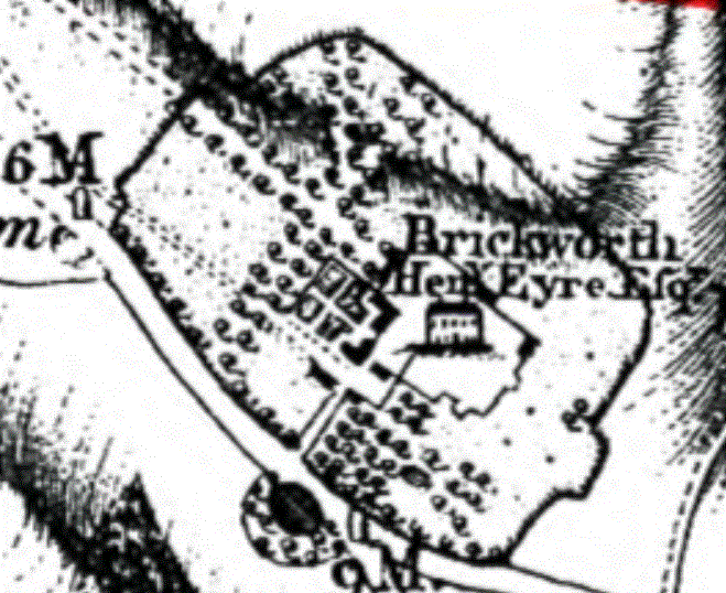
Brickworth on the Andrews and Drury map of 1773
On the wider view of the park and its surroundings below, the Pepperbox is shown as "Summer House to the top left and it can be seen how the two entrances from the summit of Pepperbox Hill ran down and into the estate. The heavily hatched line that runs across the top of the map is hill shading, which gives a good impression of the two main valleys in the area, running northwards between Whelpley and Brickworth and west along the line of the present A36 to Austins Cross at the summit of Pepperbox Hill. The double red line is a poor approximation to the hundred boundary between the Hundred of Frustfield to the south and the Hundred of Alderbury to the north. The larger part of West Dean was in Alderbury Hundred in Wiltshire, and a smaller part to the east fell in Lower Thorngate Hundred in Hampshire, not shown of course on this Andrews and Drury map of Wiltshire. [Sherfield English was in Thorngate Hundred - check others around Frustfield and prepare a map - relocate this discussion to a better position in the web site.] The boundary should run more generally along the path on the ridge between Pepperbox Hill and Dean Hill, somewhat to the north of where it is shown. Of note too are two milestones on the turnpike road, showing 6 miles from Salisbury and presumably 9 miles from Romsey at the A27/A36 junction.
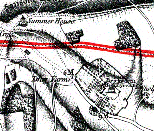
Brickworth on the Andrews and Drury map of 1773
For a full set of old maps of Brickworth, see here.
The Nelson connection is a key feature of Whiteparish's history, although one that has collected a few points of misinformation along the way.
After the death of Vice-Admiral Horatio at the Battle of Trafalgar in 1805, his older brother, the Rev. William Nelson was created Earl Nelson in his honour and in 1814 Standlynch Park was purchased for him by the nation and renamed Trafalgar Park [see Wikipedia]. Trafalgar House (also still known by its earlier name, Standlynch Park) remained the family's seat until it was sold off in 1948 by the 5th Earl Nelson.
William had no male descendant so by Special Remainder his titles passed on his death in May 1835 to Thomas Bolton, son of his sister Suzanna. Thomas's wife was Frances Elizabeth Eyre, the owner of the Brickworth estate. Thomas changed his name to Nelson and they moved to Trafalgar House and rented out Brickworth House. Thomas died just eight months later in November 1835, at which point their son Horatio became the 3rd Earl Nelson, aged 11. When his mother Frances Elizabeth died in 1878 Horatio inherited her Brickworth estate and it became part of the Trafalgar estate, as much of it remains to this day.
Horatio's guardians, until his coming of age in 1844, were his mother (the Dowager Countess Nelson), George Matcham, the Reverend Henry Girdlestone and Nelson Matcham Esq., George Matcham being the author of the 1844 book on the Hundred of Frustfield that is widely quoted across this website.
The purchase of the Trafalgar estate by the nation had included 540 acres of land in Whiteparish, listed as owned by the young Horatio Nelson in 1842 and adjacent to his mother's Brickworth estate. Across the bottom of the map here from left to right (north to south) is the pink area owned by the Dowager Countess Elizabeth Frances Nelson, a greenish area representing the Whiteparish part of the Trafalgar estate owned by the young Horatio Nelson and a dark pink area, the Whiteparish part of the Newhouse estate owned by his guardian George Matcham. In 1842 Horatio's mother was the largest landowner in the parish and Horatio the fourth largest.
The Eyre estate significantly enlarged the Nelson landholding based on Standlynch Park, which was renamed to Trafalgar Park when the nation purchased it for Earl Nelson and his descendants. The nation also contributed to the purchase of additional land adjacent with Trafalgar Park, including 540 acres in Whiteparish, making the young Horatio the fourth largest landholder in the parish, his mother being comfortably the largest. See People in 1842 for more details of the Countess Nelson and Horatio, the third Earl Nelson.
Earl Nelson, of Trafalgar and of Merton in the County of Surrey, is a title in the Peerage of the United Kingdom. It was created in 1805 for The Rev. William Nelson, an older brother of Vice Admiral The 1st Viscount Nelson, the famous British naval hero, who gained his fame in the wars against Napoléon I. The title still exists, with the Rt. Hon. the 10th Earl Nelson, who has an heir apparent. Trafalgar House (also known as Standlynch Park), the family's ancestral seat in Wiltshire, was sold off in 1948 by The 5th Earl Nelson. A full list of the Earls Nelson can be found below at The People.
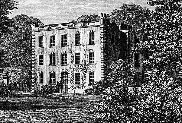
A close up of Brickworth House in 1844 from the engraving above [Matcham before page 34]
This section lists the owners of Brickworth House and below that is a list of the Earls Nelson.
Eyres of Brickworth in Burke's Commoners
The ownership of Brickworth House started with five successive generations named Giles, this always having been a popular name in the wider Eyre family, still in use today. The ownership listed here is based on Matcham's 1844 account with additional information from Genealogy websites. I've added numbers in brackets to denote successive generations and included Giles Eyre (1)'s father Thomas (0). Family members closely related to Giles Eyre (1) were resident at Newhouse, Landford, New Sarum and Eyre Court in Ireland, and the family moved to Trafalgar House when they inherited the title Earl Nelson in 1835. Brickworth House was rented out after this date and burned down during the lifetime of Frances Elizabeth Eyre (8), its land becoming part of the Trafalgar Estate in 1878 when her son Horatio Nelson (9) (ne Bolton) inherited the Eyre estate on her death. Where the direct line failed and Brickworth passed between branches of the family in the entries below, a clearer view of this inheritance can be seen here.
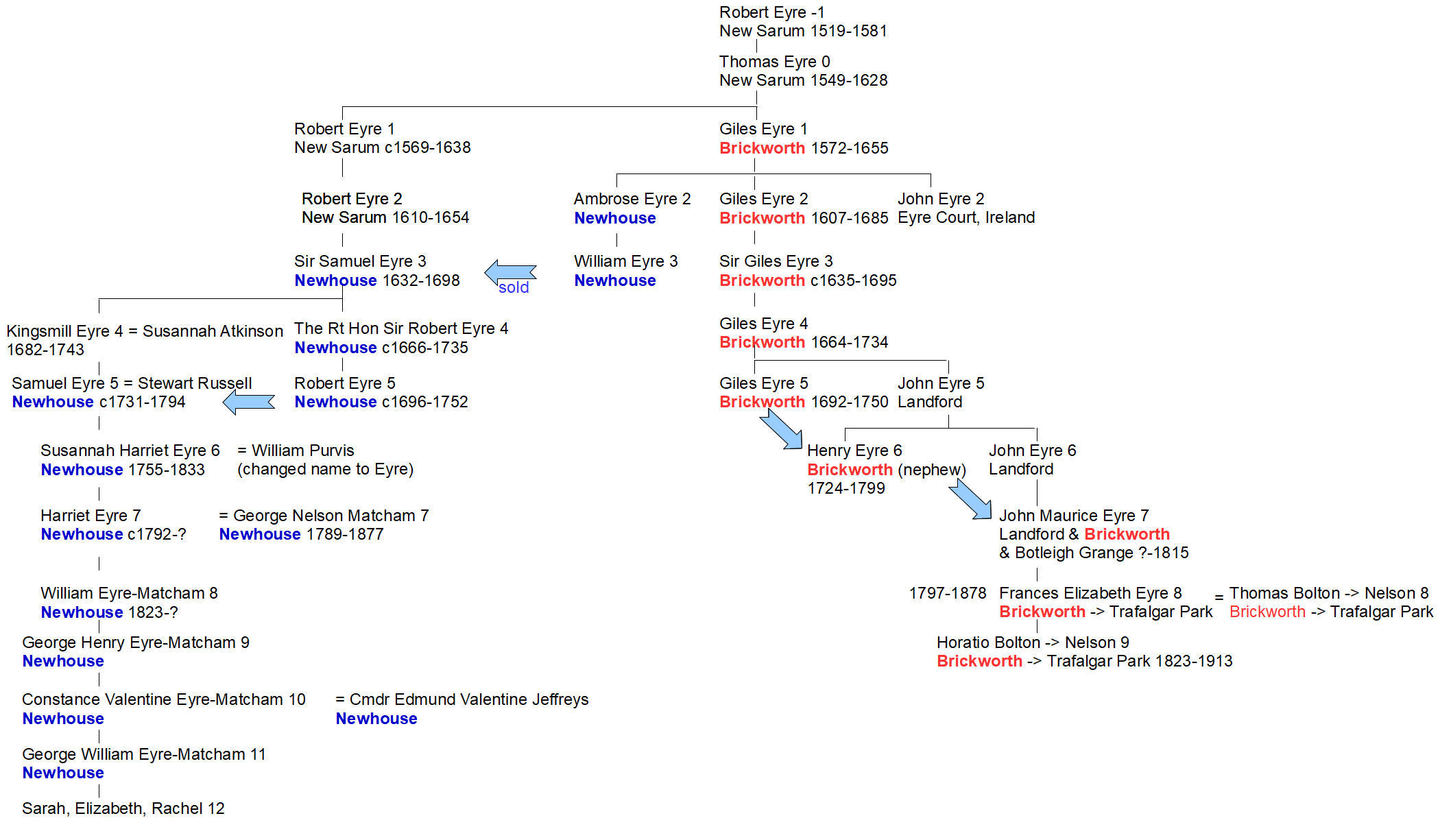
Owners of Brickworth and Eyre family tree [Needs a correction: Giles Eyre [4] died in 1728, not 1735]
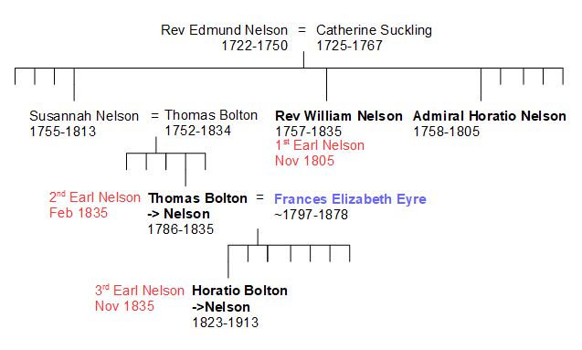
Showing the link between Frances Elizabeth Eyre and the Nelsons via Thomas Bolton
Known expansion dates and events
The extent of the Brickworth estate owned by Frances Elizabeth (Eyre, Bolton, Nelson) in 1842 can be seen as the pink area extending from the bottom left corner of the map below. The greenish area to the right of this is the land in Whiteparish owned by her son in his capacity as the third Earl Nelson, the 18 year old Horatio Nelson. The original Brickworth estate was just the part that lies in Whelpley Manor, east of today's A36 (east is at the top of this map and the A36 enters the map from the bottom left corner). The first extensions were into Abbotstone Manor (now Titchborne) where Lower Bush Farm now stands, then southwards across the south of Whelpley Manor to include Holmere Common (part of Abbotstone/Titchborne Manor). From there the area of woodland grazing now known as Whiteparish Common was added and one fifth [two fifths?] of the sub-divided Blaxwell Manor bringing the estate right up to the current A27 in the heart of the village where the Parish Lantern pub now stands.
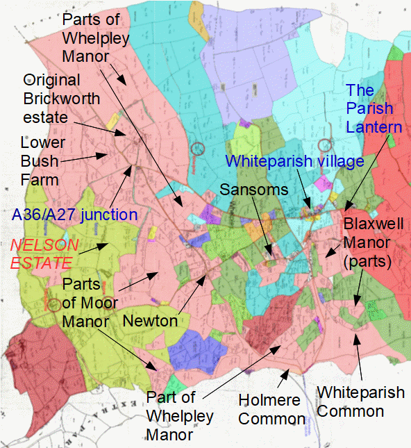
The Eyre's Brickworth estate in 1842 is the pink area extending from the top right (northwest) corner of this map
click here to explore this map in more detail
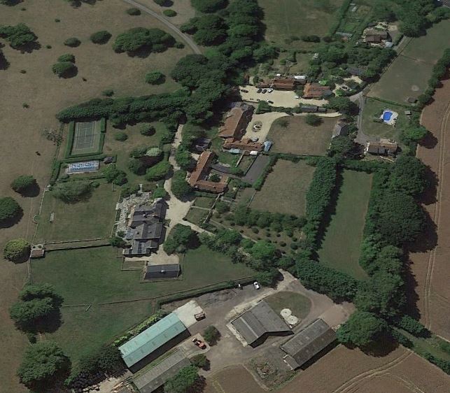
Although the A27 and A36 have both been altered since 1901, the map and Google Earth view below show that much of the modern landscape and buildings are unchanged. The two images below and the one further down the page display the Google Earth view and 1901 map separately and overlaid.
 Google 2018.jpg)
Brickworth today (c) Google 2018
 2018.gif)
1901 1:2500 OS map over Google Earth image
old-maps.co.uk and (c) Google 2018
Two lodges marked the approach to Brickworth House, and both are still there. The first is prominent at Brickworth Corner and situated to the right of centre of the bottom edge of this map. The other was on a drive that led from above the Brickworth chalk quarry (now landfill) near the top of Pepperbox Hill directly across Brickworth Down to the house; this can be seen at the top left corner of the map. This lodge is now the farmhouse for Brock Farm: see Brock Farm for more details.
By 1860 Brickworth House itself was let by the third Earl Nelson to a Mrs Strangeways. In May 1860, all the fires in the house having been lit to warm the building for Mrs Strangeways imminent return, a fire broke out in one of the rooms. Despite the hard work of numerous people in the ensuing conflagration, the internal walls were largely of timber and the main house was almost totally destroyed, leaving just the outside walls of the main house and the servants' part of the building. The newspapers reported that it was thought that the fire had been caused by a wooden beam passing through one of the chimneys catching fire. The present Brickworth House appears to have the same outline and alignment, so was probably rebuilt on the same site at that time.
Looking at the detail on the 1876 map extract below overlaid on a modern Google Earth view, it can be seen that many buildings and boundaries remain from 1876 and probably in many cases from the original layout of the area around the house. The walled garden immediately behind the house is a prominent feature and the several buildings of the farm remain unchanged in this time.
 2018 red buildings.gif) . .
. .
Left: the 1876 1:2500 OS map overlaid on a modern Google Earth view, map buildings picked out in red, map alone on the right
old-maps.co.uk and (c) Google 2018
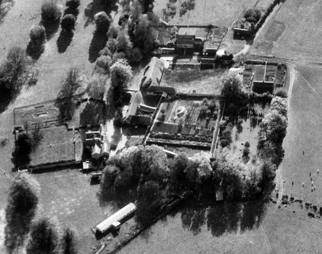
This next map shows a wider area and allows a comparison to be made of the old road layout with its several twentieth century realignments. The aerial photograph alongside, taken on 3rd November 1947, clearly shows the area and the old road alignments [part of Historic England EAW012031].
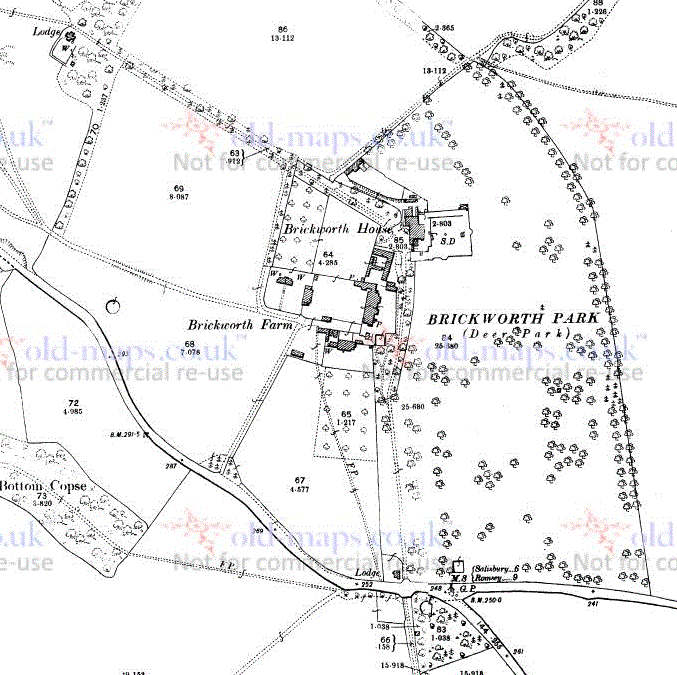

Left: Brickworth House and Park in 1901 (1:2500 Ordnance Survey Map from old-maps.co.uk)
Right: Aerial photograph 3rd November 1947 looking south. The fork of A27 and A36 is top left, Brickworth at bottom left
The road junction at Brickworth Corner has changed significantly, but enough elements of the old road alignments exist to be able to see the layout on the ground today. The old A36 is still present in the woods to the west of the A36. At Brickworth Corner it can be seen entering the woods west of the storm overflow pit by the entrance to Brickworth Quarry, from where it runs through the wood and rejoins the existing road roughly half way up the hill to Lower Bush Farm (previously Dry Farm). The lodge sits uncomfortably close to the A27/A36 junction today, but when built was alongside a straight section of road rather than a bend. At the time the A36 left the A27 at a T-junction and the relationship between the old and new roads can be seen below and on the Old Roads page. Where the garage now stands was a pond associated with Brickworth House.
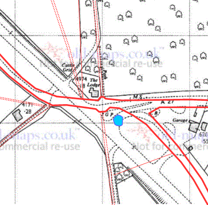
Brickworth Corner - 1966 map overlaid with tracing of 1901 roads and tracks (Ordnance Survey and old-maps.co.uk)
A new entrance gateway and gate was constructed on the A27 about 2000 across the existing farm track that runs northwards along the eastern boundary of Brickworth Park and a new drive cut across the park from there towards the position of the house. On the map below the new drive can be seen snaking its way across the park from the A27 in the bottom right corner of the map, replacing the modern entrance that was on the A36 immediately left of the lodge.
.gif)
Brickworth Corner in 2018 showing the new A27 entrance and drive across the park
(the new drive starts from bottom right) (OS Open Maps)
The present Brickworth House appears to stand on the same site as Giles Eyre's original 1605 house. This is not the same as Brickworth Farmhouse, built in 1725 during the time of Giles Eyre (4, 1664-1734) and now advertised for B&B.
.gif)
Brickworth Farmhouse in 2018 (B&B advertising photo)
See Brickworth Farm for the later history of the farm after the merging of the Nelson and Eyre estates on the death of Frances Elizabeth, dowager Countess Nelson, in 1876.
See Brickworth (Matcham) for Matcham's account of Brickworth.
Matcham: lying as it does close to the boundary, various owners of Brickworth had purchased land that had been part of Whelpley Tithing and Abbotstone Tithing.
The Brickworth estate was owned by the Right Honorable Frances-Elizabeth Countess Nelson when the 1842 Tithe Map was compiled, and the larger part of it farmed by John Bell (see Tithe Map Landowners and Occupiers for full details). The Countess had retained occupation of most parts of the estate that were woodland at the time, presumably for the purpose of hunting, and of course Brickworth House and Park itself, and the common land associated with Whelpley and Abbostone, now known as Whiteparish and Holmere Commons respectively.
The Right Honorable Frances-Elizabeth Countess Nelson (d1878), daughter of John Eyre of Landford and Brickworth owned Whelpley (?check - Matcham is confusing here) Manor in 1842 (Matcham p31). This Wikipedia link explains the Nelson family and this page gives a brief background of Frances and her son Horatio, 3rd Earl Nelson. The estate at Standlynch (now Trafalgar House) is reputed to have been purchased for the 1st Earl Nelson by the government when he complained at having such a title without an estate to go with it, and includes Horatio (to be 3rd Earl) Nelson's 1842 Tithe map holding of 540 acres of land in Whiteparish. This is not to be confused with his mother Countess Frances Elizabeth Nelson's much larger holding of 1355 acres, held in her own right as heiress of John Eyre and of course representing the end of the Eyre family line in this branch. Needless to say, this land did in 1878 pass to her son Horatio Bolton, the 3rd Earl Nelson, on her death.
[Integrate details from this reference.] From A history of Landford Appendix 1 page75: According to the 1841 Census for Whiteparish, Countess Nelson was living there (presumably at Brickworth Manor) along with her sons Edward and Henry and ten servants. Details are available online recording the extent of the property owned in 1842 in Whiteparish alone, covering some 1,356 acres. The 1839 tithe map for Landford shows that Countess Nelson owned some 600 acres in Landford and she also owned the Landford Lodge estate from 1848 to 1859, which occupied some 118 acres. In 1860 Brickworth Mansion was destroyed by fire and rebuilt. Landford Common was enclosed in 1861, with most of the land allocated to Lady Nelson (640 out of 740 acres). The Dowager Countess Nelson as she was by then, died at Landford House on 28th March 1878, having resided there the last seventeen years of her life.
The nature reserve of Brickworth Down and the Pepperbox building were given to the National Trust by the 7th Earl of Radnor in 1934. The site is always open to visit and has a small car park. The A36 carries fast traffic and visibility is poor: take great care entering from and leaving the site back onto the main road. National Trust Pepperbox Hill, National Trust trail
The Pepperbox is a tower that stands at the top of the escarment of Pepperbox Hill at the north-western edge of the Brickworth estate. It commands excellent views all round, including north-westwards towards Salisbury and from its upper level over most of the Brickworth estate and on to Southampton and the Isle of Wight.
The Pepperbox is commonly stated to have been built in 1606 by Giles Eyre, reputedly so that he could look down on his neighbours at Longford Castle, but there is good reason to question this date. As described above, Giles Eyre (1) bought the initial part of the Brickworth Estate in 1605, on which he built Brickworth House and established the deer park alongside it. It seems somewhat improbable that he would have been engaged in building a summer house or viewing tower on the top of the hill when there was the construction of a house and park to attend to, and the land on which the Pepperbox stands was not acquired by the Eyre family until rather later [add date and reference]. The listed building status for the Pepperbox (see below) describes it as early 18th century and National Trust experts are clear that there are no signs of there having been an earlier building on the site, and therein lies the clue to a more likely origin. Giles Eyre (4) inherited the estate in 1695 and Giles Eyre (5) from him in 1734, so either of these could have constructed the building in the early eighteenth century. Giles Eyre (4) had a reputation of being eccentric and was even described as a lunatic in the Parliamentary Records of his father, and is the most probable builder of the Pepperbox. It is highly likely that the 1605/6 dates commonly quoted for the building have been reached erroneously by associating the building with the wrong Giles Eyre, there having been five of them in succession, covering the time from 1605 to 1750 as detailed above. The statement in Wikipedia that highwaymen made use of it in the early 18th century seems similarly curious - the building was new at that time and it scarcely seems likely that either of the Giles Eyres of that era would have countenanced such misuse of their brand new summerhouse. This is certainly a building that attracts myths.
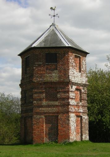
The Pepperbox in 2012
Erected by Giles Eyre (4) or (5) in the early 18th century, not by Giles Eyre (1) in 1605/6 as commonly stated (see discussion above)
1889 and 1898 and 1907: Brickworth House occupied by James Alexander Shirreff, Esq. [Kelly's Directory 1889 & 1898 & 1907].
Text below copied from The Salisbury and Winchester Journal, and General Advertiser, Saturday, June 2, 1860, page 8, column 2
WHITEPARISH. Destruction of Brickworth House by Fire.— On Sunday last the fine old mansion, known as Brickworth House, the country seat of Mrs. Strangways [sic], to the left of the road leading from Salisbury to Southampton, was almost totally destroyed by fire. It appears that Mrs. Strangways has been for some time residing in London, but being expected to reach Brickworth early in the week, fires had been lighted in some of the rooms, in order to prepare them for her reception. Early on Sunday morning flames were observed in one of the rooms, and before the servants could give an alarm they spread with fearful rapidity, and the partitions between the different rooms chiefly consisting of timber, it soon became painfully evident that the principal part of the mansion was doomed. An engine was sent for from Downton, and Mr. Gay, Mr. Gwyer, and other farmers kept their horses and water carts employed throughout the day in bringing water to the scene of the fire. Every effort was made by those present, but the only portion of the building that could be saved was that appropriated to the servants. A great deal of furniture was got out, but much was destroyed, and it is at present impossible to state the quantity of plate and other valuables in the house previous to the outbreak. The wind being high, the work of destruction was most complete, only the four outer walls of the mansion being left standing. The mansion was the property of Earl Nelson, and we understand that his Lordship is insured, although we cannot state to what amount. We must add that Mr. Superintendent Matthews and several members of the County Constabulary were in attendance, and rendered good service during the fire. It is supposed that the fire originated in one of the flues, in which a beam must have been inserted.
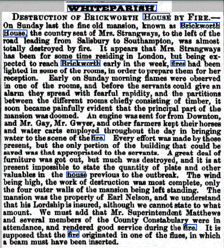
Image (c) The British Library Board, All rights reserved
Listed building description of the Pepperbox from BritishListedBuildings
Folly. Early C18, roof rebuilt c1900. Probably by Giles Eyre of Brickworth House. English bond brick, Welsh slate roof. Hexagonal plan. 3 storeys, one blocked window per face. Segmental-headed doorways to ground floor, and windows to first floor, which has 3-brick plat bands. Second floor has stepped cornice and blocked windows with timber lintels. Stepped eaves cornice. Hexagonal conical roof with weathervane. Occupies a prominent position on Pepperbox Hill, with fine views. Also known as Eyre's Folly.