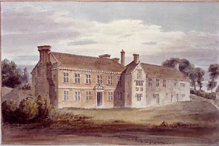
A view of Alderstone Manor House by the church painted by Buckler in 1805
A Whiteparish local history page from younsmere-frustfield.org.uk
A view of Alderstone Manor House by the church painted by Buckler in 1805
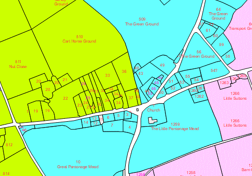
The heart of Alderstone Manor lies around the triangular village green that reaches the church in its southwest corner, includes The Green on its eastern side and also the area that is now occupied by the houses of The Triangle. As seen below on the 1842 Tithe Map, the land occupied by the green extended beyond this triangle itself both westwards and northwards. Houses were grouped along the eastern and southern edges of the triangle, and land to the south of what is now the A27 had been mostly associated with the church and parson in earlier times.

The village centre showing the village green (green) and church and meadows (yellow)
Below, the same map has been coloured to show the different manors, with the boundaries tentatively reconstructed from later ownership. This emphasises the positions of the Alderstone manor's houses, positioned round the triangular part of the green and later along the south side of The Street.
Manors at the village centre - Whelpley in green, Alderstone in blue, Blaxwell in pink
What is manifestly missing from these maps is a manor house, as a result of it being moved in 1812 from next to the church to a grand house and park at Broxmore in the east of the parish, built on other land belonging to the manor. This page is about that manor house.
We know that the old house was built, or more likely extended, in 1562, and was completely demolished in 1812 to be used in the foundations of the new house. Some earlier writers have claimed that the manor house was moved from the present Alderstone Farm in 1562, but Alderstone Farm has all the characteristics of an early 17th century farm built in the manor's open fields, and none of the earthworks and accompanying ground disturbance that would be expected from an early settlement site. My own working theory is that the manor house had always occupied the same position next to the church, and that the 1562 building merely extended or replaced an earlier building.
The rectory of Whiteparish and the manor of Alderstone had formed part of the possessions of the College of St Edmund, Salisbury. After the college and its possessions were seized in King Henry VIII's name in 1546, they were sold to one of Henry's Gentlemen of the Privy Council, William St Barbe, who thus became Lord of the Manor.
William's son Edward St Barbe inherited Alderstone from his father, and shortly after 1562 built a grand house on a prominent site close to the church. By the time Matcham (page 26) was writing in 1840, the site of the house had apparently been lost other than that it was variously described as being "on an eminence close to the church" and "adjacent to the church".
Happily there remain two known records of the location and appearance of the house in the form of the 1773 Andrews and Drury map of Wiltshire and the watercolour above of 1805 by John Buckler (1770-1851), an architect and Fellow of the Society of Antiquaries, who had a commission to paint the churches of Wiltshire in watercolour for Richard Colt-Hoare of Stourhead [John Buckler in Wikipedia]. While visiting and painting the churches, he also painted other significant buildings he saw, and the St Barbe Manor House was included among these. Given the accuracy and precision of his work, it has been possible to use the painting to reconstruct the the house in the form of the 3D model shown below and to position it onto Google Earth views of the centre of Whiteparish at its most likely location.

An extract of the Andrews and Drury map of 1773: the red arrow indicates the presumed St Barbe Manor House
For detail at this level see Wiltshire Record Society
For the full map of Wiltshire see Wiltshire Record Society (the second map is detailed: click in the red zone in the lower right corner for Whiteparish)
The house shown to the south of the church on the Andrews and Drury map (above) fits with what we know of the size, shape and orientation of the St Barbe house. While this seems the most probable site for the house, various other possibilities have been carefully considered and assessed in reaching this conclusion. One useful map in this respect is Bowen's turnpike strip map of around 1725, which shows all the properties alongside the turnpike, now the A27. A description of the analysis of other possible positions is included on this page. As described below in more detail, the house appears to have stood across what is now the Memorial Hall and surgery car park, just above the drive to Steeple Barn, stretching northwards into what is now part of the churchyard. Buckler's viewpoint for the painting was a point in the old, narrower, churchyard, alongside the church.
On 21st April 2016 contractors digging a trench across the surgery car park for the new Memorial Hall broke into a well that coincides precisely with the location deduced for the house, and it is almost certain that this was the water supply for the house, either within or immediately behind it. We are fortunate that Peter Claydon was on hand to take photographs before the well was capped, and his pictures are shown below: I am very grateful to him for permission to display them here. Further discussion of this well and its well house can be found on this page.


Three pictures of the well uncovered in April 2016 in the surgery car park. Photographs courtesy of Peter Claydon.
Alderstone Manor, estate and Great Tithes were bequeathed to Edward St Barbe in 1562, his father William of Ashington Somerset having purchased the property in 1546. Edward built himself a new grand house close to the church, which stood there for somewhat over 250 years until 1812, when it was demolished and the materials used in the foundation of an even grander house at Broxmore Park.
1546 William St Barbe (S)* bought St Edmund's College and its property, including Alderstone Manor, estate and Great Tithes, for £400
1562 Edward (T) his son was bequeathed the estate on his father's death and built a new house next to the church, pictured above a few years before its demolition
1616 Edward (U) inherited on his father's death
1642 Edward (V) inherited on his father's death
1671 George (W), Edward's brother, inherited when Edward died without issue
1693 George, George's son, inherited the estate on his father's death
1720 George died, leaving two sons, John of Ridgeway aged about 8 and Edward about 10. George had surviving siblings
Poole, Anne, Mary and Lucy, and his wife Sarah also presumably survived him
1722 George Treby, Esq. bought the estate "from John's coheiresses" [Matcham]. Were these were George's sisters, with his brothers possibly already
being established themselves?
1725 George Treby sold the property to Robert Bristow, of Micheldever, Hants
1736 Robert's son Robert of Micheldever inherited
1773 The house was shown, immediately south of the church, on a map by Andrews and Dury
1776 Robert's son Robert of Broxmore Park inherited
1805 A detailed watercolour painting of the house was made by Buckler (see top of page)
1812 The Manor House was demolished and the materials used in the foundation of an even grander house at
Broxmore Park
* The letters in brackets identify individuals, as used by Matcham (facing page 10) and also in the St Barbe family link below.
Further details of the Whiteparish St Barbe family during this period
More detailed discussion of the house and its position and form
| Dynasty | Monarch | Events in this reign |
| Tudor | 1547 Death of Henry VIII | |
| 1547 Edward VI | 1549 The Book of Common Prayer | |
| 1553 Jane Grey | ||
| 1553 Mary I | 1554 Mary I married Philip of Spain | |
| 1558 Elizabeth I | 1588 Spanish Armada | |
| Stuart | 1603 James I | 1605 Gunpowder Plot |
| 1625 Charles I | 1642 English Civil War started | |
| -- | 1649 The Commonwealth | 1653 Oliver Cromwell became Lord Protector |
| Stuart | 1660 Charles II | 1666 Great Fire of London |
| 1685 James II | 1685 Battle of Sedgemoor | |
| 1688 William III and Mary II | 1690 Battle of the Boyne | |
| 1702 Anne | 1707 Act of Union to create Great Britain | |
| Hanover | 1714 George I | 1720 South Sea Bubble |
| 1727 George II | 1745 Bonny Prince Charlie invaded England | |
| 1760 George III | 1775-1783 American War of Independence | |
| 1811 Regency (George IV) | (1815 Battle of Waterloo) |
William St Barbe of Ashington in Somerset was a layman of the King's privy chamber. On the death of the provost of St Edmund's College Salisbury in 1543 he was granted a royal dispensation to hold this office as a layman rather than priest. The College had been founded in 1269 by Bishop Walter de la Wyle and dedicated to St Edmund of Abingdon, who had been a treasurer of Salisbury Cathedral. It was intended to have thirteen priests headed by a provost, to serve the parish of St Edmund as well as the duties of a religious foundation. The advowson and rectory of Alderstone had been given to the college as part of its endowment in 1339 and land in Alderstone added in 1347. On 17th June 1546 the Mayor of Salisbury took formal possession of the college for the use of King Henry VIII shortly after the dissolution of the monasteries. As a favoured courtier of the king and as provost, William was ideally situated and purchased the College and all its properties, including Alderstone Manor, its estates and its Great Tithes, from the king two months later for the sum of £400.
For further detail see The College of St Edmund in Salisbury, British History online and William St Barbe.
William St Barbe was styled "of Ashington, Somerset" and may not have moved to Alderstone.
William's son Edward inherited the manor and church on the death of his father in 1562 and he did make Whiteparish his home, and indeed the seat of this branch of the St Barbes for the next 160 years; see St Barbe family for an account of the family during this time.
A new farm was later built at Alderstone Farm, the farmhouse judged by Matcham to be of the early seventeenth century and certainly much later than 1546, and other authorities since have repeated his assessment. The farm was most likely built by another Edward St Barbe (U), William's grandson and Edward's son. This farmhouse is, of course, still there: see Alderstone Farm for further details, including the listed building assessment of its key features and the subsequent history of the farm. As already mentioned above, it is very doubtful that this farm was ever the manorial centre, situated as it is in the manor's open fields without any signs of an earlier manor site around it, and my own conclusion is that the 1562 manor house by the church was on the same site as the earlier manor house.
The 1562 house appears in a late watercolour painted in 1805 (at the head of this page) to have been in three (possibly four) parts and not to have been constructed according to a single plan. The 1805 picture of the house unsurprisingly shows signs of having been altered significantly since 1562; 240 years is a long time. The right-hand section looks earlier and shows signs of alteration in the upper storey to match windows in the left section. The central projection, possibly a staircase, is stylistically correct to be part of Edward’s building, if not from his father’s time. It bore the crests of both William and Edward, each with their wives, as well as that of Queen Elizabeth I, so one might wonder whether maybe the work had been started by the father and completed by the son, Elizabeth having come to the throne four years before William’s death. The left section is of a later date, although whether before, during or after Anthony Hungerford’s time is harder to be sure, his crest being prominent over the door.
Careful 3D analysis of the building, referred to below, suggests that the right section of the building has a hipped roof at the join, whereas the left section has a simple end gable. My current thinking is that both halves of the building were present in some form in 1562, as the central projection was of that date and overlapped both. This suggests that the house that William St Barbe erected was a modification of an earlier manor house and that the left section stands on William's "new" building work but has been rebuilt since. As recorded by Matcham the armorial bearings on the central projection are of Queen Elizabeth, St Barbe impaling Little (William's wife) and St Barbe impaling Beswick (Edward's wife). The right hand part gives the impression that it had been modified to add three or four matching windows at first floor level, although with no attempt to match the decorative mouldings of the newer section, or that the new section copied and embellished that earlier set of windows.
The painting dates from 1805, some 240 years after the recorded date of construction of the house. Matcham's engravings of the armorial bearings on the central projection are probably too detailed to have been copied from the watercolour, and it is to be understood from his text [locate exact reference] that the originals had been preserved in the later house at Broxmore Park, so that the engravings are probably copies of the original stonework. This is a good point, though, to issue a caution regarding another of Matcham's engravings. His illustration of the 1562 St Barbe Manor House is clearly derived from Buckler's watercolour and faithfully reproduces the architecture of the house itself, but some not insignificant changes have been made to provide a grander setting - the wall to the left of the building replacing Buckler's skyline and the gardener tending roses on the front of the building being inventions of the nineteenth century.
I've suggested the fourth part of the house referred to above to account for the chimneys visible in Buckler's painting. At the rear of the building in the watercolour can be seen a row of three apparently closely placed chimneys. One of these is on the right hand end of the nearer half of the building, one of the four chimneys standing at the ends of the two halves. This leaves two chimney stacks to account for, and I suspect that these stood alongside a rearward extension to the older half of the house, possibly serving a kitchen and associated rooms. The artist Buckler was also an architect, and given the very precise perspective used in the painting - and indeed in all his set of paintings of Wiltshire churches and notable other buildings - it seems reasonable to assume that he has been accurate in his portrayal. A speculative outline and position has been arrived at, using 3D modelling, for this rear part of the house, to make better sense of the presence of these two chimneys, although other configurations would doubtless fit the evidence. The 3D analysis suggests that these chimneys must have been positioned very close to the back wall of the main building, as otherwise their height would have been excessive.
The well photographed by Peter Claydon sits close behind the centre point of the house - a very plausible position for a well. With the artist sitting alongside the southwest corner of the church, the foreground hedge loosely sketched in the painting would pass across the foreground as he has shown. The images below show the house superimposed on the modern background.
The 3D model of the house has been constructed directly from Buckler's watercolour, shown below coloured from the watercolour but with construction lines added for clarity.
.jpg)
The two views below show this model dropped into the modern landscape across the churchyard and Memorial Hall car park, firstly viewed from above the church and secondly from above the car park entrance by the surgery.
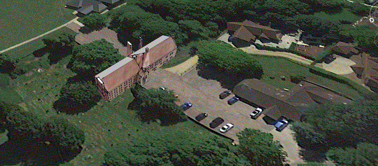
Reworked position of the manor house 1.12.2020 (Background image Copyright 2020 Google)

Reworked position of the manor house 1.12.2020 (Background image Copyright 2020 Google)
To illustrate the position of the well with respect to the building, the well has been added schematically in the view of the back of the house shown next. As described above, the precise position of the well or placing of the chimneys in this area is not known.
.jpg)
Rear view of the house showing one possible location for the well
The following sequence of four maps has been used to decide exactly where the house stood. The first of these, Andrews and Drury of 1773, is very much a sketch map, but shows a small building immediately south of the house. This building is shown in Buckler's watercolour, and the accuracy of other buildings on his other views suggests we can take this as a real building. The maps of 1876 and 1925 also have a small building shown that had gone by 1976. Tying up the later maps and the painting has allowed the position of the building to be determined quite precisely, with the well providing further confirmation that the correct site has been selected. It isn't known what this building was, although it is worth being clear that this is further up the hill alongside the pond, and not the site of the well. These maps also show the earlier churchyard boundary, visible in the foreground of the watercolour, and the way the churchyard was extended later across roughly half of the footprint of the house at a date between the 1876 and 1925 maps.
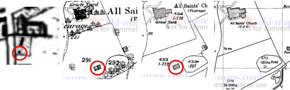
Maps confirming the position of the house (1773, 1876, 1925, 1976)
The house passed on through the family from father to son (see the link above for details) until 1671, when Edward the then owner died without issue. Edward had brothers who were twins, George of Southampton and John of Salisbury. Matcham records that Alderstone manor and the house passed on through John’s son John and his son, another John, whose two surviving daughters Henrietta-Maria and Ann sold it to George Treby on their father’s death in 1722. In the short term, though, Edward’s wife Mary Mason married Anthony Hungerford and from his prominent crest over the door it’s clear that they continued to live there. Anthony Hungerford was an interesting character, having been a secret agent on behalf of the Royalist cause in the English Civil War.
The village link to Lyndhurst and its St Barbe school and museum follows from the other twin, George. After George’s great grandson Charles died in 1826, his widow Anne St Barbe gave £220 in 1835 to purchase a half-acre site on which to build a school for poor Lymington children, and this is now the St Barbe Museum. Charles St Barbe (1750-1826) had earlier established the first bank in Lymington in 1788, and his son Charles (find dates, clearly not 1876-?) was mayor five times. George Treby sold the house after only three years into Robert Bristow in 1725, starting a new chapter in the history of Alderstone.
The Bristows made the Manor House their home for the next 86 years until 1812 (list owners), but by then the fashion for living in a grand and prominent manor house in the village had passed. The house was demolished and used in the foundations of a new house at Broxmore Park, still on Alderstone land, but in a parkland setting and on a very much grander scale. The site of the old house was lost.
The Bristows have an interesting history of their own. Since three successive generations at Alderstone/Broxmore Park were named Robert (and also the previous generation?) accounts are quite confusing to read, and which Robert is described in some of the source material is ambiguous. Dates and the appended letters used by Matcham from the family archive will be used here to identify individuals as clearly as possible.
The grandfather of Robert (1688-1737) migrated to Virginia in 1660, building up his fortune as a merchant. A violent local rebellion in 1676 brought him back to London, where he invested in property and maintained valuable trading links with Virginia and the West Indies. Robert's father became MP for Winchelsea, Kent, Recheck and continue, based on this link and Matcham's Bristow pedigree on page 11.
Collecting Bristows for a separate page and the heading above
.... Robert Bristow (1662-1706) of London (MP Winchelsea) = Catherine Woolley (-1751)
1725 Robert (2) (1688-1737) of Micheldever = Sarah (-1736-), daughter of Sir John Warde of Squerries, Kent
1737 Robert (-1776) of Micheldever, = (1) Sarah (-1794-), daughter of John Philipson of Spring Gardens and Ashtead (2) Mary, daughter of Richard Harding
1776 Robert (1773-) of Broxmore Park = Miss Twine of Ramsbury
Lots more details of 1662 and 1688 Robert Bristows at
Robert Bristow 1662-1706
Robert Bristow 1688-1737
In the interests of clarity and readability, not all the research considered in reaching the above conclusions has been described on this page. For the inquisitive reader, further references, modelling and maps can be found on this page, where the position of the house and its development and history are examined in greater detail.