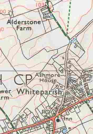
This page is about the modern Alderstone Farm, which is thought to date from the early 17th century and was certainly created no earlier than 1546 when the manor was bought from King Henry VIII by William St Barbe. The farm forms part of Alderstone Manor, whose earlier history can be found here: Alderstone Manor. There are extensive notes and further detail of the Manor and Tithing and the early history of the manorial centre at Alderstone, but this is not available on the public part of this website.
Contents
- Introduction
- Farmyard and farmhouse
- The Nunn family in 1842, Arthur, George and George Esquire
- Could this have been the original centre of the manor as some have suggested?
- References
Introduction
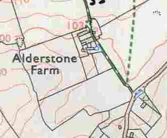
The farmhouse at Alderstone Farm dates from the early 17th century, and this is probably when the farm was established. This house and its farmyard are a mile north of the manor settlement in the demesne fields that were reserved for the use of the lord of Alderstone Manor. One of the three demesne fields is thought to be the one on the right as you approach the farm along the access road from Dean Lane, while the other two are on the left side of the sunken and hedged track that runs directly on from the farm up the hill to the edge of what had in earlier times been sheep down, where the hedges still stop. This would have been a new centre for the farming associated with the lord of the manor's land.
By 1842 the farm occupied 402 acres (a newspaper advertisement for the farm dated 1815 also lists it as 400 acres), the whole of the part of the manor between the church and the top of Dean Hill, all to the west of Dean Lane. The strip of land running for just over a mile eastwards along the ridge from the top of the hill was also part of the farm (a modern footpath runs along this land). Most of the farm was arable in 1842 and farmed by Arthur Nunn, who lived in the farmhouse. It seems most likely that the whole of this area was also part of the farm in the early 17th century. Although initially it may have served just the three demesne fields, this seems unlikely.
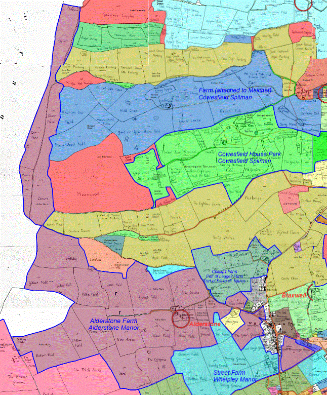
The manor was owned by St Edmund's College in Salisbury from 1338 to 1546, and this may have affected the way the manor developed. While large parts of Whelpley manor to the west of Common Road ended up as small farms, this didn't happen in Alderstone, where the manor remained as an estate in the hands of the lord of the manor. Alderstone Farm occupied most of the western part of the manor and the eastern part became the Broxmore House estate when the manor house was moved there from next to the church in 1812. The relatively small area of strip fields remaining in 1842 were on the Hampshire boundary, all lying to the east of Broxmore House, and it seems likely that tenants had their allocations moved there from the western part of the manor to free up the open fields there to be part of Alderstone Farm.
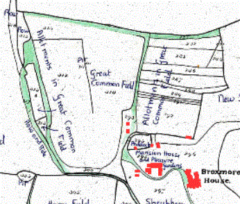
Great Common Field in 1842, the site of the last open fields near Broxmore House (this map has east at the top and north on the left)
Some of the fields shown are in Cowesfield Spilman, but historical ownership mixed up these strips of the two manors
The uppermost field edge shown is the Hampshire boundary
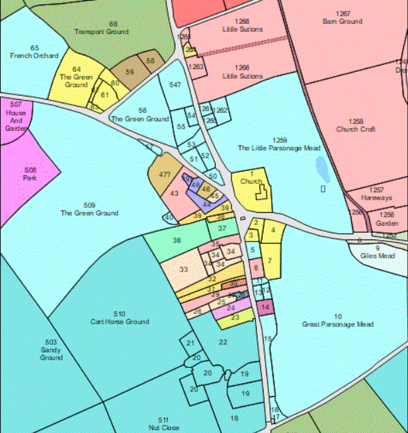
The map below is the 1842 Tithe Map, coloured according to the land occupier, with Alderstone Farm shown in purple and a red ring to show the location of the farm buildings.
Alderstone Farm in 1842 in purple, farmed by Arthur Nunn
North is to the left of this map, east at the top
See Tithe map occupiers for the full map, which may be more up to date than this extract
Alderstone Farm appears to have been established in the demesne fields of Alderstone Manor, land that was reserved for the use of the Lord of the Manor and cultivated for him by his tenants. In his Wiltshire Archaeological Magazine article of 1967, C C Taylor refers to a 1330 Extent to an IPM (a post-mortem inquisition) on Ingelram Berenger, lord of the manor, listing three arable fields, Forton (20 acres), West Field (23 acres) and Lynacre (14 acres) as belonging to the demesne and listed separately from a further 32 acres in the open fields [WAM Vol 62, 1967, page 90]. Taylor equates these with fields on the 1842 Tithe Map named Four Downs, West Field and Nine Acres, which he says have roughly the same areas.
.gif)
Four Downs, West Field and Nine Acres on the 1842 Tithe map as traced and labelled by Phoebe Merrick
These are the fields identified by C C Taylor as the demesne fields of 1330
North is to the left on this map, with east at the top
Farmyard and Farmhouse
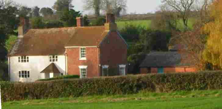
The farmhouse at Alderstone Farm is a listed building dating from the early 17th century and the area taken up by the farmyard is probably of the same age. The house is L-shaped and has an extension built in the 1840s. The early part is constructed of rendered cob, almost certainly based on chalk given the chalk subsoil, while the 1840s part is of bricks in English bond. This is a building with a lot of historical interest, as made clear by its Grade II listing (see its entry here in British Listed Buildings and the summary of these details below).
 .
.
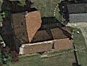
The farmhouse has a wing behind not visible from this angle, aerial view (c) 2024 Google
William St Barbe (S) bought the manor from King Henry VIII in 1546, and his son Edward (T) inherited it in 1562 and lived to 1616, after which his son Edward (U) was lord of the manor until 1642. Edward (T) built the manor house by the church in 1562 and from the date of the house it was probably him or his son who created this new farm centre in the centre of his demesne fields.
 .
. 
Alderstone Farm buildings in 1842 from the Tithe Award and today
Comparison of the 1842 map above with the modern ones alongside and below shows that at that date there were farm buildings on the now unoccupied area to the right (east) of the modern track through the farm, north of where Alderstone Farm Cottage stands today. This cottage might conceivably be the same building as the one marked on the 1842 map, but I haven't examined it for clues to its age. A useful point of reference on the two maps, as well as the shape of that right hand section of the boundary, is the pond shown at the south end of the farmyard on the two maps above.
Further analysis of these maps and a range of aerial photographs is under way to establish the 1842 boundary line on modern cartography as well as to look for any sign today of buildings of that time. The area has been extensively used for storage, for instance of hay and straw bales, and any signs may be buried under later accumulation of soil or erased by movement of farm machinery.
.gif) .
.  Google 2017.jpg)
The modern Alderstone Farm Left: map 2024; Right aerial view (c) Google 2017
Farmhouse listed building status
From British Listed Buildings
Farmhouse. Early C17, enlarged 1840s. Rendered cob, English bond
to 1840s build, tiled roof, brick stacks. L-plan. 2-storey, 3-
window. C20 door and hipped porch to right of early build, 4-light
and 1-light casement to left, 12-pane sash with keystone to flat
arch to right. First floor has 4-light and 3-light casement and
12-pane sash with keystone to right. Two pairs of diagonally-set
stacks, probably C19. Left return has C20 casements and glazed
door to rear wing. Right return has blocked window and 12-pane
sash wth keystone to ground floor. Rear wing of early build has
outshut with 3-light casement, C19 build has half-glazed door and
12-pane sash. Interior: planked doors with strap hinges, chamfered
beams with bar stops, cellar beams have ogee stops. Open
fireplaces in hall and kitchen in wing have chamfered lintels with
runout stops. Timber-framed partition between hall and wing. This
farm was property of St. Barbe family in mid C16. (Unpublished
records of RCHM (England), Salisbury).
The Nunn family in 1842, Arthur, George and George Esquire
We know from the 1842 Tithe Award that Alderstone Farm was farmed by Arthur Nunn in 1842, and we can get a glimpse of the Nunn family members living and working in Whiteparish at that date through this Award and the 1841 census, supported by the church registers and one of the memorials in the church.
Arthur Nunn was baptised in All Saints Church Whiteparish in 1815 and as his parents are recorded as living here in 1841 and 1842 presumably lived his childhood in the village. He is not listed in the 1841 census, but in the Tithe Award of 1842 he was listed as the tenant of Alderstone Farm, 402 acres, the fifth largest land user in the parish. An earlier newspaper advertisement of 1815 had stated "Alderstone Farm Whiteparish ...description... 400 acres chiefly arable may be had immediately or tenancy entered on at Michelmas next with access to put in wheat and turnips beforehand".
Alderstone farm in purple, farmed by Arthur Nunn in 1842, the farmyard is ringed in red
East at the top of the map, north to the left
See Tithe map occupiers for the full map, which may be more up to date than this extract
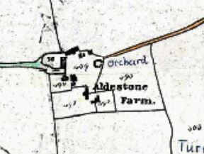
Arthur's parents George and Rachel Nunn owned the properties 38 and 39 on the 1842 Tithe Award map, two houses with gardens and a yard immediately east of the present Post Office and Stores, these now being 1 Church View Cottage and Wisteria House. Their 1841 census return shows them with two servants and an independent family, Henry and Susan Thomas and their one year old daughter Edith Emma Thomas. Given the more recent history of Wisteria House as the surgery and George's profession of surgeon, might it be justifiable to wonder whether he and his family lived in Wisteria House and the Thomas family in 1 Church View Cottage?
.gif) .
. 
38 corresponds to 1 Church View Cottage and 39 to Wisteria House (misspelt on this map), both possibly still the same buildings today
For a clearer view of the map, right click and select "open image in new tab"
In addition to the two houses, gardens and yard, George Nunn rented a yard and The Green Ground (11 acres, 509 on this map) that lay behind Wisteria House and separated it from Maria Percy's house on Dean Lane (507 and 508), where two young children, George Gilbert Nunn aged 1 and Ellen Catherine Nunn aged 3 months were recorded in the 1841 census. Exactly whose children these were is to be determined. Arthur's sister Emma had a son George, but as we'll see below, he would have been 4 or 5 at that date and she had died three years earlier in 1838, so this is presumably a different George.
 .
.
Left: Land ownership in 1842; Right: land owned and occupied by the Nunn family in the village centre
[The .odg drawing for the right hand map is in the folder Tithe Map Photographs, snip from it directly]
One of George and Rachel Nunn's daughters Emma married George Faulkner in 1833. We know they had a son George in 1836, recorded in the church baptism register as George Nunn, not Faulkner. Sadly Emma died in 1838, and she has a memorial in the church. As mentioned above, George and Emma's son George presumably isn't the one year old George Gilbert listed in the census, as he would have been around 5 by that date.
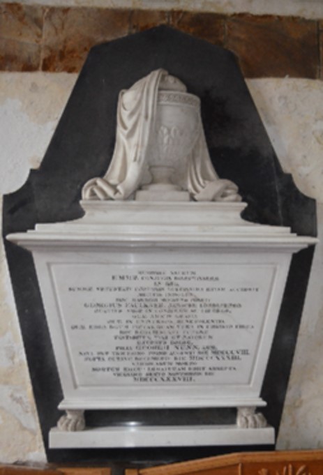
Emma Nunn/Faulkner's memorial in church
More details of the Nunn family can be found here: Nunn family in 1842.
It is worth noting that the 1842 Tithe Award lists two George Nunns separately as occupying property, one styled George Nunn Esquire and one simply George Nunn, while George Nunn is also listed as owning property. As the property occupied by George Nunn Esquire is the yard 40 and The Green Ground 509, I have shown these areas in a slightly different green on the map above.
Could this have been the original centre of the manor as some have suggested?
Alderstone Farm has been mooted in the past as the original centre of Alderstone Manor, but after many years of detailed study I am now convinced that it was a new farm set up at some time before 1842, when it is shown on the Tithe Map. Some of the arguments in favour of this theory are:
- The area around the farm shows no sign of the heavily eroded land surface that would normally accompany the site of an early settlement
- Field boundaries in the area are straight, consistent with division of common arable fields and inconsistent with early assarting and field expansion
- The farm is only approached in one direction and that is a branch off one of the local roads. An old manor would normally have roads or paths reaching it from several directions. The track running up the hill only goes as far as the edge of what used to be sheep down. There are no other existing tracks or lines of roads visible on aerial photography
- The manor house of 1562 was next to the church [reference] and it seems very likely that this itself was a rebuild or extension of an earlier building. The triangle formed by Bunkers Hill, The Green and Dean Lane/Ashmore Lane seems to have been the centre of the early village green, as evidenced by 1842 field names in the area
It seems likely that having purchased the manor, the St Barbes may have given any remaining tenants allotments in the arable open fields in the eastern part of the manor, near what was to become Broxmore House. This would have freed the open fields north of the village to become a separately farmed area. The last strips in the parish were in that eastern area and are shown on the 1842 Tithe Award map and the recorded owners and occupiers suggest that strips were no longer allocated by that time.
References
This is a working section containing selected notes and references, not a comprehensive reference list for the page. Most references can be checked by following links above to other pages on this website. The References page contains extensive and very comprehensive references for the whole site, but this is only accessible on the private version of this website.
Brian Skelding 25.1.1997: there is a well under the kitchen floor of Alderstone farmhouse. [1991 in list of Church Vicars]
(Jenny) Newspaper 1815: Alderstone Farm Whiteparish ...description... 400 acres chiefly arable may be had immediately or tenancy entered on at Michaelmas next with access to put in wheat and turnips beforehand.
C.C. Taylor: North of Whiteparish village the present Alderstone Farm was built ... [in the early 17th century] ... to judge from the extant building, and certainly after 1546 when the land there was acquired by one William St Barbe. This man bought the Manor of Alderstone and built a fine house near the church. Alderstone farm was presumably intended as the centre from which the actual farming of the estate was to be run. [C.C. Taylor, Whiteparish, a study of the development of a forest-edge parish, WAM Vol 62, 1967, p 96 (full article pp 79-102)]