
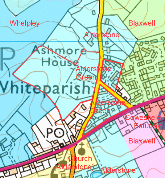
The manor started around the triangular green just to the north of the church, now filled with houses.
Contents of this page
- Introduction
- The early form of Alderstone Manor and Whiteparish village
- Early records of Alderstone Manor
- People at Alderstone Manor up to 1338
- 1338 The manor comes under St Edmund's College Salisbury
- 1546 Alderstone Manor seized for King Henry VIII and sold to William St Barbe
- 1546 to 1722 St Barbe Family in the manor house by the church
- 1724 or 1725 The Bristows in the manor house by the church
- 1812 to about 1939 The Bristows at Broxmore House and Park
- Broxmore House in the War years
- After the war
Introduction
Alderstone is the manor at the centre of Whiteparish village and includes the church, whose rectors (and later vicars) were appointed by the Lord of the Manor until 1338 and again after 1546. History gave the manor a complex structure, made up of several disconnected areas of land scattered around the parish, as illustrated on the map below.

.gif)
Left: Alderstone Manor outlined in red, with one area running up the hill from the church to Dean Hill, then along the hill top, and a larger part southeast of the three Cowesfield manors along the county boundary
Right: the layout of the eight Whiteparish manors, Alderstone in blue
Alderstone manor's Green occupied the triangle between The Green, Bunker's Hill on Romsey Road, and Dean Lane (Ashmore Lane), as well as other land to the north and west of this. The houses of the manor stood round this green and especially around the triangular area. Expansion continued along the north side of The Street and west of Newton Lane as people from the mediaeval village of Whelpley relocated to the Whelpley land there. Four of the eight Frustfield manors have land in close proximity, and Whiteparish now occupies parts of Whelpley, Alderstone, Blaxwell and Cowesfield Esturmy manors. To provide some orientation, the 2012 extension to the Memorial Ground is in the manor of Blaxwell, while the Parish Lantern and entire south side of the A27 east of there is in the manor of Cowesfield Esturmy, as well as the north side of the A27 eastwards from the entrance to the Pains Firework Factory. Older inhabitants will still remember that Cowesfield Nurseries was on Romsey Road opposite Chalkpit Farm and the Pains Firework Factory entrance, now renamed as Old Nursery House.
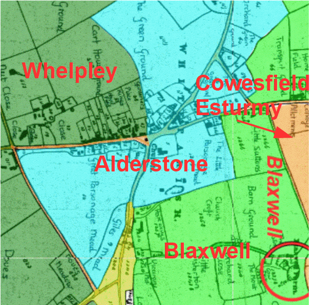
The way Whiteparish has developed around Alderstone and the church onto three other manors, Whelpley, Cowesfield Esturmy and Blaxwell
The base map here is the 1842 Tithe Map
The early form of Alderstone manor and Whiteparish village
The names of fields on the Tithe Map of 1842 help uncover the early layout of the manor, with houses grouped around a village green, now bounded by Bunker's Hill on Romsey Road, The Green and Dean Lane (Ashmore Lane). A larger area of additional village green lay to the west of Dean Lane just to the north.
By 1842 ownership was starting to become more fragmented, while still retaining much of the original manor structure. The triangle labelled as The Green Ground forms the core of the manor, with houses set around it, and together with the larger area also labelled The Green Ground represents open public space, doubtless used by livestock.
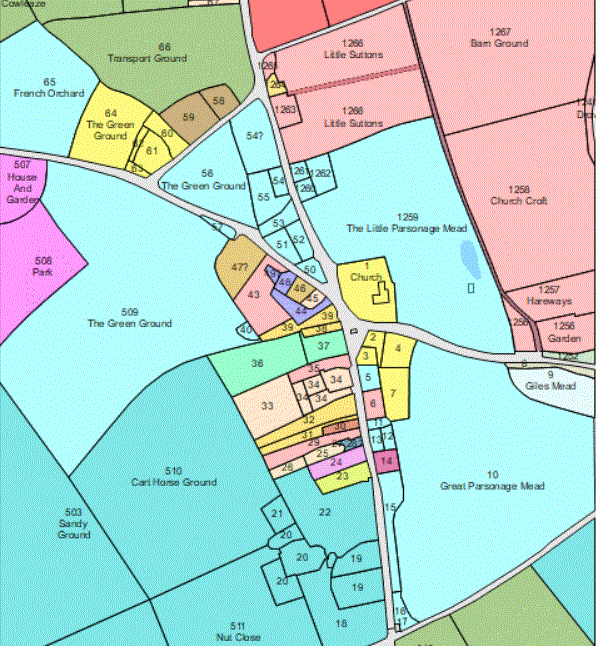
The centre of Alderstone Manor in 1842
Alderstone pale blue; Blaxwell pale pink and dull green; Cowesfield Esturmy dark pink; Whelpley dark blue; church and associated land yellow; other owners various colours
The village green areas outlined in red
Early records of Alderstone Manor
The first record we have of Alderstone comes from 1086 in the Domesday Book, when Aldred is recorded as holding one hide of land in 'Frustfield', the administrative Hundred that included the modern parish of Whiteparish.

First line: Aldred ten' FERSTESFELD. Ipse tenuto T.R.E. & geld p(er) una hida...
Aldred holds (land in) FRUSTFIELD. He held it in the time of King Edward and paid tax for one hide...
Comparing Alderstone with the other Domesday entries places it as a significant but relatively small manor at the time. The largest manor in Frustfield was Whelpley, clustered around a triangular green next to the present Whelpley Farm and described as 3 hides. Two of the three Cowesfield manors existed too, with sizes of 2 and 1.5 hides. These faced each other across another triangular green, the western corner of which is still there as Cowesfield Green. In terms of size, Alderstone and Moor come next, with 1 hide each, and then there were two much smaller holdings of 1.5 and 1 virgate (a virgate was nominally a quarter of a hide, making these 3/8 and 1/4 of a hide respectively). The mediaeval settlements at Whelpley and Moor are no longer there, but are still present as significant earthworks (see those pages for details).
The hide and virgate were measures of tax assessment that varied somewhat, but the hide is traditionally and nominally considered to have been about 120 acres and the virgate a quarter of that, 30 acres. This puts Whelpley at 360 acres, Cowesfield Esturmy 240 acres, Cowesfield Spilman 180 acres, Alderstone and Moor 120 acres each and the two smaller units 45 and 30 acres respectively. The rest of the land at that time would have been waste, a mixture of woodland and open areas according to the type of soil, with various rights being held. In very rough terms, 120 acres equates to the area of the later manor between the church and the modern Alderstone Farm.
People at Alderstone Manor up to 1338
Not having been mentioned in Domesday Book in 1086 and probably not existing at the time, the present church building is considered to have been built around 1200, although reusing some pieces of sculptured stone from an earlier building dating to earlier in the 12th century, and therefore perhaps having first been built around 1150 [see All Saints Church for full details]. The earliest surviving documents confirming the existence of the church date from somewhat later, in 1278, 1291 and 1297. An earlier document of 1255 records three smallholders holding land directly from the crown, Robert de Alderstone, John Sprot and Bartholomew de Alderstone, but we have to wait until the time of Edward I (1272-1307) for a document naming a Lord of the Manor, although at that date it seems that Andrew de Chartres had probably just died and was represented by the King as guardian of his lands in appointing a rector. Surviving documents show that this was around the time when the name "Whiteparish" started to be used for the expanding village, la Whytechyrche in 1278, evolving to a recognisable Whyteparosshe by 1301.
Subsequent Lords of the Manor were Alan la Zouch in 1310 and then Ingelram Berenger from before 1319 until around 1327. Ingelram was followed in 1327 by William de Sparsholt and Johanna his wife, and William their son. The 1327 document lists the land associated with the manor, which by then included Broxmore (Brockesmor), Cotmore (Cotemor) and Docksmore (Dosxmor), and this shows that by then the manor had expanded into the land between the Hampshire boundary and southeast of the Cowesfield manors (including Bunny Lane). That part of Alderstone Manor is nowadays thought of as part of Cowesfield, but the hamlet of Cowesfield Gate, Broxmore and Ash Hill were historically part of Alderstone manor, a point that will be of great significance later in this history of the manor. The name Cowesfield Gate comes from the gate across the road between Alderstone and Cowesfield Wood that stopped livestock moving between the two manors. Nowadays we might expect to see a cattle grid serving the same purpose, for instance, in the New Forest, but in the 1960s when I was a child there were still gates across the roads at the entrances to Ditchling Common, north of Brighton in Sussex. It was always a treat for us children to leap out to open and close the gates to allow the car to be driven through. It was about this time, in 1324, when the church was last referred to as Alderstone Church in surviving documents, and since then it has always been referred to as Whiteparish Church, although as already mentioned, it remained the Lords of the Manor of Alderstone who chose and appointed rectors until 1338 and vicars since 1546.
1338 The manor comes under St Edmund's College Salisbury
A few years later, in 1338, the fortunes of the manor changed radically, when Robert Woodford, described as a citizen of Salisbury, purchased the advowson (the right to appoint the rector) together with 4 acres of land in Alderstone, and arranged for the titles to be transferred directly from the lord of the manor, John, son of William de Sparsholt, to the Provost of St Edmund's College in Salisbury, Peter de Wymborne [Matcham p.6 & british-history]. The college's initial endowment made by Walter de la Wyle in 1269 had proved inadequate and the College had been financially stretched since its foundation. There was a second transfer of the rest of the Sparsholt land in Alderstone in 1347 to St Edmund's College under a later Provost, Robert Loe [Matcham p.7 & british-history]. For the next 200 years the college acted as Lord of the Manor and made use of the revenue raised, with successive Provosts now appointing vicars rather than rectors. It has been suggested that the expansion of the manor to the land east of Cowesfield dated from this period, but the earlier reference quoted above shows that this had been part of the manor already, before the manor was gifted to the College. Control from the College explains the paradox that there didn't then appear to be a manor house in the manor until after the College and all its property had been seized and sold by King Henry VIII to William St Barbe in 1546. We can only speculate on where the earlier manor house had stood prior to 1338, but there is some evidence that the building of a new manor house by William's son, Edward St Barbe, in 1562 was in fact the expansion of a building already there, quite possibly on the site of the original manor house.
1546 Alderstone Manor seized for King Henry VIII and sold to William St Barbe
William St Barbe was one of Henry VIII's favoured courtiers. He served in the Royal Household as Gentleman of the Privy Chamber under Henry VIII and was to continue later under Queen Elizabeth. Henry appointed William as Provost of St Edmund's College in 1543, a post he strictly wasn't entitled to, not being in holy orders. Henry simply changed the rules in the following year to allow him to continue to occupy the position, and it is not hard to suppose that this was a convenient way of preparing for the unchallenged seizure of the College. As related elsewhere in this website [link], on the 17th June 1546 Robert Griffith, the Mayor of Salisbury, together with William Webber, Thomas Chaffyn and Henry Goldston, took formal possession of the College and its property for the use of the King, this property including the manor of Alderstone and the chapels in Moor and Whelpley, the one at Cowesfield Louveras having already ceased to be used and its property incorporated into the manor [last listed Chaplain appointed 1464]. Two months later, Henry sold St Edmund's College and all its property to William for the sum of £400. William went on to sell the College and most of its possessions, but retained Alderstone Manor and, I deduce from other documents, the property of the chapel of St James at Moor and, probably, of St Lawrence at Whelpley.
1546 to 1722 St Barbe Family in the manor house by the church
William (S), Edward (T), Edward (U) and Edward (V) from the St Barbe family continued to live in the manor house alongside the church from 1546 until the turn of the eighteenth century. Edward St Barbe (V) died childless in 1671 and although his brother George (W) inherited [link to Lymington St Barbe museum], his mother, nee Mary Mason, married Anthony Hungerford, and the couple continued to live in the house. Indeed, they put Anthony's crest prominently over the front door. Anthony died in 1703. When George St Barbe died in 1720, his two sons were aged 8 and 10, and the property passed to his surviving siblings Poole, Anne, Mary and Lucy, and wife Sarah. The subsequent sale of the manor to George Treby in 1722 referred to these as George's coheiresses.
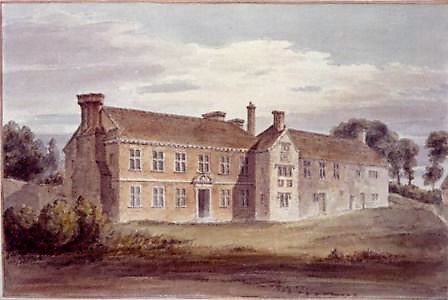
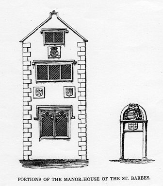
The manor house that stood next to the church from 1546 to 1812
The crests shown on the diagram are of Queen Elizabeth I, William St Barbe and his wife Elizabeth Little, Edward St Barbe and his wife Christian Beswick, and over the door, Anthony Hungerford
George Treby didn't retain the manor for long and had sold it by 1724 or 1725 to Robert Bristow (2), starting a new chapter in the fortunes of the manor.
1724 or 1725 to 1812 The Bristows in the manor house next to the church
Having bought the manor in 1724 or 1725, Robert Bristow (2) died in 1737 (1736 by some accounts), leaving as heir his son Robert Bristow (3), aged about 25. Robert (3) married twice, firstly Sarah Philipson [spelling?] leaving a daughter Susanna, then secondly Mary Harding, by whom he had a son Robert Bristow (4) and three daughters. Robert (4) appears to have been aged about three when his father died in 1776. He inherited the manor and continued to hold and use the house until he was about 39.
Robert Bristow (4) had been based largely in Piccadilly and wanted a base in Alderstone for entertaining, so in 1812 he had the manor house by the church demolished and used the materials in the foundations of a grand house at Broxmore, in the eastern part of Alderstone on the Romsey side of Cowesfield. This house stood just south of Rowden's Farm at at the top of Bunny Lane, with a park extending across much of the eastern part of the manor and farmland stretching on across rented land owned by Lady Fremantle in Cowesfield Louveras to the north.
1812 to about 1939 The Bristows at Broxmore House and Park
When Robert Bristow (4) (1773-1853) had Broxmore House and Park constructed and the old manor house by the church demolished in 1812, he would have been aged about 39. His future wife, Miss Sophia Twine (1813-1896) was born in the following year in Ramsbury. Working back from the birth of Robert and Sophia's first recorded child Ada-Sophia in 1841, when Sophia would have been aged 28 and Robert 68, it would seem likely that they had married around 1840, and they went on to have a second child Robert (5) in 1847. Robert Bristow (4) died six years after this in 1853 at the age of 80.
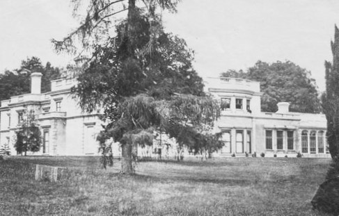
.gif)
Left: Broxmore House and Right: the detached part of Alderstone in which Broxmore House was built, close to the boundary with Cowesfield Louveras
The red line leaving the bottom right corner of the map towards Sherfield English is the A27
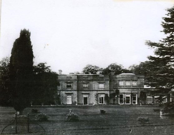
Another view of Broxmore House
Sophia (Twine->Bristow) then married Charles Durie (1815 - 14th November 1893 [Ancestry]), who had been born in Chatham in Kent. Their wedding would have been between the death of Robert (4) in 1853 and 1858, when a newspaper reported a fire in the stables of Major and Mrs Durie at Broxmore [reference]. On the 24th April 1870, when the church was reopened after the Butterfield restoration, Charles and Sophia had been due to donate a piece of land for a churchyard extension, to be consecrated at the opening ceremony, but Sophia was severely ill and not at home. Instead, the land was donated a few months later on the 21st June 1870.
Sophia became patron of the living on the death of her husband Robert Bristow (4) and appointed her younger brother the Rev W Twine (b.1818) vicar of Whiteparish in 1878 [church list]. The vicar's census return for 1881 is shown below, with wife Mary, daughter Sophia M(ary?) aged 27 and son Lawrence J aged 31 and living at 12 The Street. The Rev W Twine presumably moved on to another parish in 1889, when Sophia Durie (Twine/Bristow) appointed a new vicar, George Augustus Starkey. George was the son-in-law of W Twine, so quite possibly married to W's daughter Sophia M(ary) listed in the 1881 census return. There is a further appointment of a vicar in 1893 recorded on the church list but not elsewhere.


The 1881 census entries for the Rev W Twine and his family in Whiteparish
Charles Durie died on 14th November 1893 and was buried in Alderbury (a possible family connection there to follow up), and his wife Sophia (Twine/Bristow/Durie) appointed a new vicar Julian Pattison in the same year. Sophia Durie (Twine/Bristow) died three years later in 1896. Two years after that, in 1898, Kelly's Directory reported that Broxmore House was occupied by Henry Webley, Esq., but this was possibly a temporary arrangement, as Miss Bristow was living there subsequently, as seen below.
In 1897 when the next vicar was appointed, it was Mrs Bull and Miss Bristow who were patrons of the living, and these were almost certainly sisters and the surviving daughters/children of Robert Bristow (4) and Sophia Twine. The new vicar was the Rev John Casketter James, and in 1902 or 1903 they appointed the next vicar too, the Rev Charles Frederic Metcalfe, whose son Russell was born in the vicarage in 1904 and left us a detailed account of his early life at the vicarage from then until his father moved to a new post in 1815 (see that link). Robert (5), the brother of Mrs Bull and Miss Bristow had died in 1873 at the age of 26.
Whiteparish 100 Years says that Miss E S Bristow left the house in the 1930s, and this is almost certainly the Miss Bristow of 1902/3 mentioned above. As the house was commandeered in the war by the Army, it is possible that it was in or about 1939 that she moved out as a result. Miss Bristow had declined to sell the field that is now the Memorial Ground to the village, so it was in 1947 that Mr Bristow Bull, almost certainly the husband of Mrs Bull of 1902/3, sold the field as a recreation ground for Whiteparish. 1947 was also the year when the Broxmore estate was divided up and sold as separate units, and the house demolished, as described in more detail below. Reading between the lines, I suspect that Miss Bristow lived at Broxmore House, while her sister and husband, Mr and Mrs Bull, lived elsewhere, possibly on the estate, of course.
To help with the complexity of the account in this section, a list has been retained below of the events and people described above. Errors are always possible, so please do let me know of any you spot and I'll make the necessary corrections. A further comprehensive list of owners and events can be found at the foot of the page on Broxmore House and Park, covering a wider date range (not yet uploaded at 29.3.2024).
- 1773 Robert Bristow (4) born 1773-1853
- 1813 Sophia Twine born 1813-1896
- 1815 Charles Durie born in Chatham, Kent, 1815 - 14th November 1893 [Ancestry]
- 1840 Speculated date of marriage of Robert Bristow (4) to Miss Sophia Twine of Ramsbury
- 1841 Ada-Sophia Bristow born
- 1847 Robert Bristow (5) born
- 1853 Robert Bristow (4) died
- ???? Charles Durie married Sophia Twine (Bristow) [Ancestry]
- 1858 Fire in the stables of Major and Mrs Durie
- 1870 24th April Mrs Durie severely ill and not at home when the church was reopened after the Butterfield restoration
- 1870 21st June Charles Durie and Sophia his wife donated land for the churchyard
- 1873 Robert Bristow (5) died, so didn't inherit the estate
- 1878 W Twine b.1818 became vicar [church list of vicars], almost certainly the younger brother of Sophia Twine/Bristow/Durie, both born in Ramsbury 5 years apart
- 1881 W Twine listed as vicar in the census (listed as W Twyne in some transcriptions)
- 1889 Mrs Durie as patron of the living appointed George Augustus Starkey as vicar. George was the son-in-law of W Twine, the previous vicar from 1878 to 1889, and presumably married to the Rev W Twine's daughter Sophia M(ary?) [see Church Vicars]
- 1893 Julian Pattison appointed as vicar, presumably by Mrs Durie (Twine/Bristow)
- 1893 14th November Charles Durie died and was buried in Alderbury [Ancestry]
- 1896 Sophia Twine/Bristow/Durie died
- 1897 The Rev John Casketter James appointed as vicar by Mrs Bull and Miss Bristow
- 1898 Broxmore House occupied by Henry Webley esq. [Kellys Directory]
- 1907 Living in the gift of Mrs Bull and Miss Bristow [I assume Mrs Bull was nee Bristow]
- 1930s Miss E S Bristow left the house [Whiteparish 100 Years] (possibly as late as 1939)
- 1947 (around) Mr Bristow Bull sold the field for the recreation ground [probably the husband of Mrs Bull and this implies that both Mrs Bull and Miss Bristow had probably died by then?]
- 1947 Broxmore House was demolished, the estate was broken up and sold in parts
Broxmore House in the War years
Broxmore House was commandeered in the war by the Army, and 133 Company was stationed there, comprised of four platoons: A, B, C and workshops, plus headquarters staff. The officers and staff were based and billeted in the house while the men were billeted in the stable blocks on three sides of a courtyard. Where there had been livestock, the buildings out on the estate were used as workshops and housed many of the Company's lorries, eighteen per platoon, being Morris C 38s or Bedford three-tonners. There were two men to each lorry and each of the three Platoons A, B and C were divided into three sections of six lorries and twelve men. Various anecdotes survive from this era, and make for entertaining reading [for instance, see WW2 People's War and Broxmore House and Park].
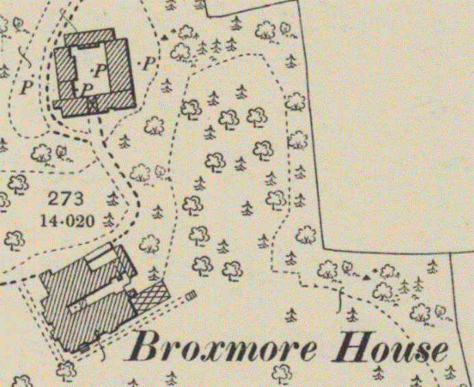
Broxmore House and stables in 1900 (survey date)
After the war
Understandably the maintenance of the house suffered during the war years. It is unlikely that the Bristows/Bulls or their descendants moved back into the building, and in 1947 the estate was divided up and sold and the house demolished. The sale particulars from 25th November 1947 are available at Historic England, in which the estate was divided into the following parts to be sold separately:
- Broxmore House - presumably bought for demolition
- Ash Hill House
- Morrisholt Farm
- Ash Hill Cottage
- Broxmore Farm
- West Entrance Lodge
[Add a map here showing these properties]
I've found no further references to Alderstone Manor after 1947. The Broxmore estate was the larger part of the manor, and this had been divided up and sold, leaving the core of the manor around the church and up to the top of Dean Hill, most of which is now Alderstone Farm. I suspect that the farm was sold at the same time as the 1947 sale of Broxmore, and that Mr Bristow Bull and his descendants lived elsewhere. The local vicar is no longer appointed by the Lord of the Manor and despite their history as part of Alderstone manor, the farms and houses resulting from the breakup of the extensive Broxmore estate are now thought of as part of the modern Cowesfield, itself considerably enlarged from its original three manors by this addition. Slightly ironically, a large part of Cowesfield Esturmy manor, which stretched up Romsey Road to the Parish Lantern, is now thought of as part of Whiteparish rather than Cowesfield.
Kellys Directory 1898
Historical Description Direct link to this section
WHITEPARISH, on the borders of Hampshire, and on the road to Southampton, is 2 ½ miles south from West Dean station on the Salisbury branch of the London and South Western railway, and 7 south-east from Salisbury, in the Southern division of the county, Frustfield hundred, Salisbury union and county court district, Salisbury and Amesbury petty sessional division, rural deanery of Amesbury (Alderbury portion), archdeaconry of Sarum, and diocese of Salisbury. The church of All Saints is an edifice of flint and stone, in mixed styles, consisting of chancel, nave of four bays, aisles, north porch and a small wooden belfry at the west end, containing a clock and 3 bells: there are several monuments to the Eyre and St. Barbe families, and memorial windows to the Bristow family: the church was renovated in 1869—70, and affords 300 sittings. The register dates from the year 1559. The living is a vicarage, net yearly value £ 108, with glebe (£4) and residence, in the gift of Mrs. Bull and Miss Bristow, and held since 1897 by the Rev. John Casketter James M.A. of Trinity College, Dublin. Here are Wesleyan and Primitive Methodist chapels. Charities to the amount of £6 10s. yearly are distributed in clothing. Broxmore House, now occupied by Henry Webley esq. is an elegant and spacious mansion, and the grounds and scenery around the house are beautiful and picturesque. Brickworth House, the property of Earl Nelson, is now occupied by James Alexander Shirreff esq. Cowesfield House, the seat of William Frederic Lawrence esq. M. P. J.P. stands on the southern slope of the Dean Hill, and commands extensive views over the country, including the New Forest and the Isle of Wight. Earl Nelson and W. F. Lawrence esq. M. P. are lords of the manors; Mrs. Bull and Miss Bristow, Mr. Lawrence and G. H. Fort esq, are the principal landowners. The soil is chalk, sand and gravel; subsoil, chalk. The chief crops are wheat, barley and turnips. The area is 6,316 acres; rateable value, £5,503; in 1891 the population was 1,037 in the civil and 1,074 in the ecclesiastical parish.
Earldoms, 3 miles south, is now included in Landford parish.
National School (mixed), built in 1846, for 160 children; average attendance, 125; & supported in part by an endowment.
[Kelly's Directory of Wiltshire (1898)]