
For further detail see Harestock maps and notes.
Harestock is on the north side of the A36 roughly 400 yards/metres northwest of the Newton crossroads. The early maps of 1773 and 1806-7 show buildings at Harestock on both sides of the road and the will of Henry Marshman relating to Harestock Farm is dated 1720 [Twenty deeds relating to Harestock Farm in Whiteparish and property in South Marston... Reference 464/56 at Wiltshire and Swindon History Centre]. The Place-Name Society claims that Harestock was first mentioned in 1576, [The Place Names of Wiltshire, English Place-Name Society], the reference being to "Hoare", i.e. Matcham's 1844 Hundred of Frustfield book or possibly one of its companion volumes. Matcham's Hundred of Frustfield mentions Harestock on page 47, but gives little information and all the dates associated with the family of Heyraz that he gives there lie between 1254 and 1349: there is no mention of the date 1576, which therefore presumably came from another source. The 2 inch to the mile survey sheet for the first edition Ordnance Survey map, survey in 1806-7, is very similar to the 1773 Andrews and Drury map, but uses the modern spelling of Harestock. Extracts of these maps are shown below.
What is now Harestock Cottage was originally a semi-detached pair called Harestock Cottages, built before 1876 and combined into a single house since 1966. It seems quite likely that the 1842 Tithe Map entry 783, two cottages and gardens, owned by the Countess Nelson and occupied by William Phillips and "another", is the same pair of houses, but the clarity of my copy of the map is insufficient to be certain [look at the original map in Chippenham].
Today (2023) there is a small group of farm buildings set back to the north of the road a few yards further north, accessed directly from the A36, and further buildings immediately southeast of Harestock Cottage, these, along with the cottage itself, being accessed from further southeast along the old line of the A36.


Harestock in 2023 (not visible on the public version of this website for copyright reasons)
All that remains of Harestock and Harestock Farm now is a pair of cottages north of the A36 a little to the west of Newton crossroads. Between 1773 and 1925 there was also a small cluster of buildings on the other side of the A36. By 1966 these had gone and only the two Harestock Cottages remained, along with outbuildings behind them. A cluster of buildings in the next field to the northwest has expanded significantly between 2002 and 2020 as shown by Google Earth historic imagery, and in the next field to the north a sand pit was operated between 1934 and 1944.
Harestock Cottage is constructed in Flemish bond, where each row of bricks contains alternate stretchers and headers, i.e. bricks laid alternately along and thorough the wall. To see this on the illustration below, right click the picture and select open in new tab, when the picture can then be enlarged to show the brick detail. Flemish bond was used from the middle of the 17th century, especially for the facades of architecturally refined buildings [e.g. https://housing.com], placing an earliest possible date of around 1650 on the building.
 2023.jpg)
Harestock Cottage today (2023)
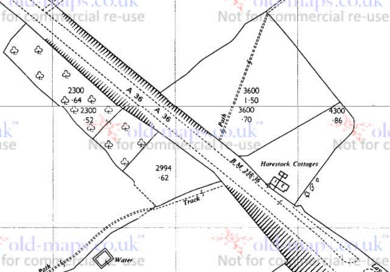
The first map record of Harestock comes from the Andrews and Drury map of 1773, where it is shown as Haire Stock and had buildings both north and south of the 1753 turnpike road that linked Salisbury to Eling via Landford and Ower - now the A36. The milestone seven miles from Salisbury on this road can be seen immediately northwest of Haire Stock on the map extract below as "7 M", with a schematic view of the milestone alongside. The survey for the 1st edition Ordnance Survey maps made in 1806-7 shows a very similar layout, with the milestone label indistinct in this copy.

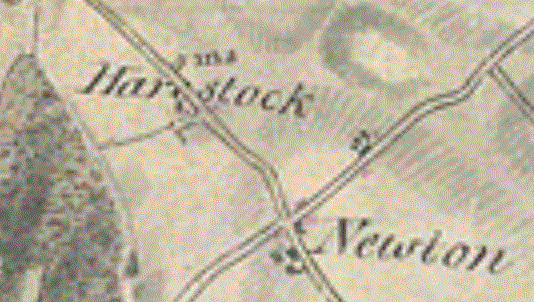
Harestock on 1773 Andrews and Drury map.gif and 1806-7 1st Edition Ordnance Survey
The 1842 Tithe Map shows the same group of buildings together with their fields and lists the owners and occupiers of each land area. At that time the land was owned by James Bridle and farmed by Isaac Pizer, amounting to an area of some six acres. James Bridle also owned other land to a total of 12 acres, and in addition to this six acres Isaac Pizer farmed the ten acre Whelpley Meadow just to the west of Chadwell Farm and owned at the time by Robert Cooper of Whelpley.
By that date Whelpley Manor had been separated from Whelpley Farm and sold to the Eyre family at Brickworth. Most of the Whelpley Manor land that lies between the A27, A36 and Common Road had by then been divided up into many smallholdings and small farms, with Street Farm and the fields across from Whelpley Meadow to the village side of Hop Gardens still part of the land owned by Whelpley Farm. By this date the Eyre family at Brickworth had bought up much of the land along the A36 and this was still in the hands of the Countess Nelson, born Elizabeth Frances Eyre and the heiress of the family estates. It would pass to her son Horatio and into the Nelson estates on her death in 1878. Harestock remained independently owned on the edge of the subdivided section of Whelpley Manor.
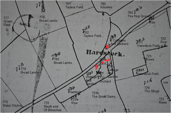
Three versions of the 1842 Tithe Award Map are shown below, with a fourth further down the page. The fourth map was overdrawn by Phoebe Merrick with field names added from the schedule. On that tracing the field 780 should be marked Broad Lands. The three versions of the map immediately below show a direct photograph of an independent copy of the original map, one with my own tracing overlaid and labelling, and the tracing on its own. In particular I've retained the distinction between different field boundary types on the tracing. This emphasises that Taylors Field was in two parts and Broad Lands in three, the latter possibly being cultivated in rotation along with the Tipple Field nearby, one of the open fields of Whelpley Manor in mediaeval times. The method of reproduction used by the Chippenham History Centre to produce my own and Phoebe's copies doesn't copy the buildings well, so buildings are difficult to interpet on both copies [to be updated after consulting the original map].
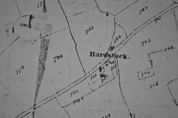
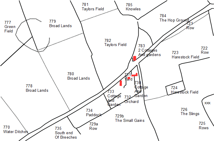
Harestock on 1842 Tithe Map (east to top of map)
Three versions - copy of map, overlaid with tracing, tracing alone
Right click and select "open in new tab" to view larger image (works with all illustrations)
The next two maps show 1842 owners and occupiers by means of a colour overlay on Phoebe's map. Both emphasise the area associated with Harestock very clearly, with James Bridle's land in blue on the left hand map, rented by Joseph Pizer in yellow on the right hand map. See Tithe Map Owners and Tithe Map Owners for the full coloured maps, which are regularly updated and corrected, so may be more up to date than the images here. The pink area on the left map was owned by the Countess Nelson, farmed by John Bull (grey), and the green owned by Henry White, farmed by Stephen Parsons (green). The dark red area on the right hand map was the two cottages and gardens of the present Harestock Cottage, two cottages at the time owned by the Countess Nelson and occupied by William Phillips and another unnamed individual.
 .
.

1842 Tithe Map, left: landowners; right: occupiers
Moving to more recent maps, the 1876 1:2500 Ordnance Survey map shows the greatest amount of detail, while the one from 1901 shows the buildings themselves more clearly. Both show the pair of semi-detached cottages north of the A36 with their outbuildings, and the 1876 map details a network of paths dividing up the areas behind the cottages that were presumably laid out as gardens.
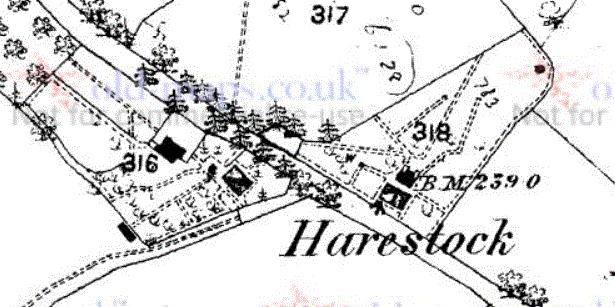
Harestock on 1876 and 1901 1:2500 OS maps
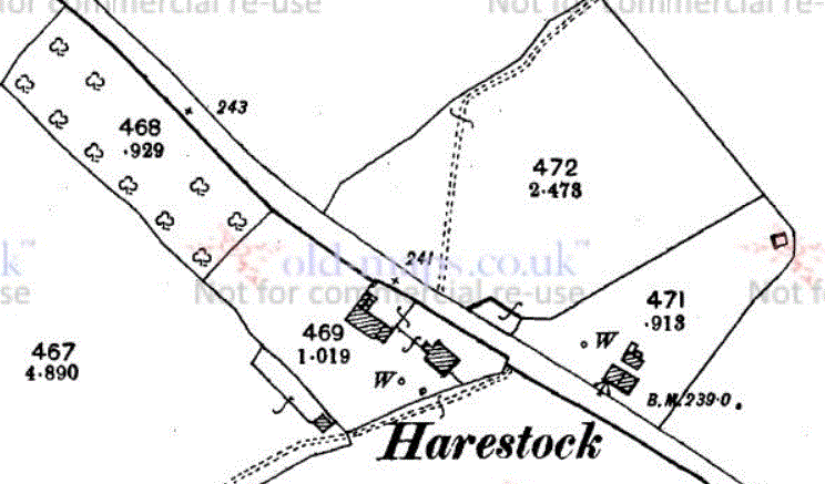
Further buildings had been erected by 1925 to the south of the A36, but between then and 1966 all the buildings south of the road were removed, including the house, leaving two areas of orchard and the 0.62 acre area in which the farm buildings had stood, as well as Harestock Cottages across the road. By 1966 the A36 had been improved and straightened, leaving the old road as a layby alongside the new carriageway southeast of Harestock Cottages. A cutting on the south side of the new road alignment encroached on what had been the farmyard area, and need for this strip of land may have been the reason for demolition.
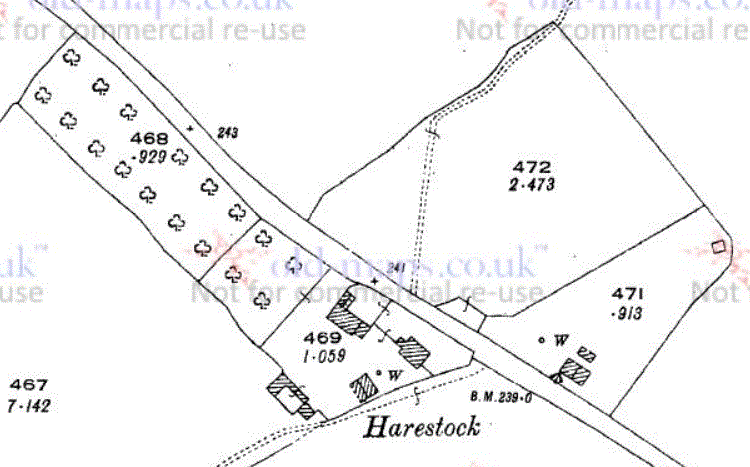
Harestock on the 1925 (left) and 1966 (right) 1:2500 OS maps
A wider view of the 1966 map below shows a Harestock Farm Sand Pit to the north in 1966 alongside a 1947 aerial photograph. These show three different sand pits, all of which have been short lived: a large on on Whites Farm to the right and a smaller one west of Harestock Cottages in 1947, and a large one further to the northeast on the 1966 map. There are papers in the Chippenham History Centre relating to a sand pit in the years 1934 and 1944, likely to refer to the smaller one on the aerial photograph [update after consulting these papers]. Google Earth has historical imagery of the site at various dates between 2002 and 2020, and the 1966 sand pit field appears to have been in use for grazing and possibly hay making in later years. Without a visit it isn't clear whether the pit is still there with smoothed edges to allow cultivation, or whether the area has been filled in.
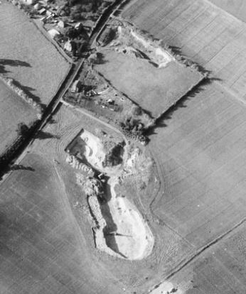

Left: Sandpits in 1947 (Historic England)
Right: Harestock on 1966 1:2500 OS map showing a later sand pit (also on 1962 1:10560 map, not on 1926 one)
For the records associated with the Harestock Farm Sand Pit in the Wiltshire and Swindon History Centre dating from 1934-1944, Reference F12/125/12, see here.
As discussed in detail elsewhere in this website, the boundary between Abbotstone and Whelpley manors broadly followed the line of the old A36. On the 1842 Tithe Map the shape of 782 Taylors Field and 783 2 Cottages and Gardens at Harestock suggest assarting of land in an eastward direction along the A36. These areas of land are not far from the edge of Tipple Field, one of Whelpley's open arable fields (see Whelpley Common Fields [change title and filename accordingly]), suggestive of continued clearance of the common grazing/woodland that still exists along the A36 as Holmere and Whiteparish Commons southeast of Newton. The earliest written record of Newton was in 1289. On balance it has the look of a relatively late settlement rather than being Saxon in origin, although this date predates the earliest records of Harestock by several centuries. The three Broad Lands fields here (Phoebe's tracing incorrectly labels 780 as Taylors Field) are alongside a known Whelpley open field, Tipple Field, and may have formed part of the Whelpley open fields that were cultivated in rotation.
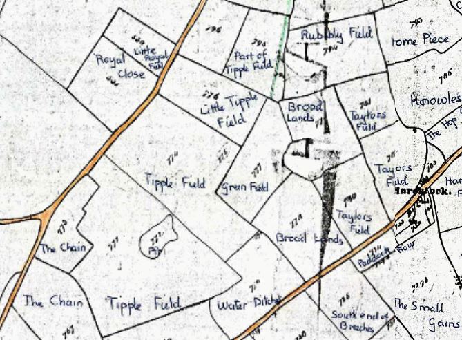
Tipple Field and Harestock (Phoebe Merrick tracing: the bottom left field labelled Taylors Field should read Broad Lands)
This tracing doesn't preserve the distinction between solid and dashed lines on the original
By the time of the 1842 Tithe Map the Eyre estate at Brickworth had bought up much of the land along both sides of the A36, and this complicates the clear assignment of a boundary.
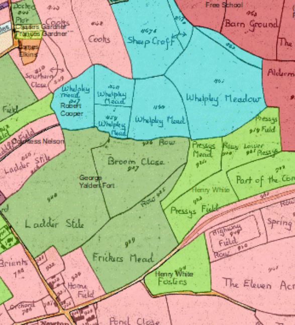
The map showing occupiers 1n 1842 shows Taylors Field north of the A36 and the Harestock land to the south of the road in pale green. This was owned by James Bridle and occupied by Joseph Pizer. In the 1841 census Joseph Pizer aged 35 had styled himself a Yeoman Farmer, but the word "Yeoman" had been crossed out. Also living there were his wife Elizabeth aged 30 and their five children, Julia 11, Frances 9, James 7, Emma 4 and Edwin 1. Joseph's land use was mixed: the orchard and paddock listed as pasture, Taylors Field as arable and an additional 10 acres in Whelpley Meadow belonging to Robert Cooper as meadow. Whelpley Meadow is land locked, lying the other side of Newton, north of Chadwell, south of junction between Hop Gardens and Clay Street and west of Common Road.
Joseph Pizer features again in the 1851 census, aged 52, with 1799 listed as his year of birth, Elizabeth age 46, born 1805. The list needs checking, but the following are listed in 1851, as well as Joseph and Elizabeth: Julia 21 (1830), Frances 18 (1833), James 16 (1835), Emma 14 (1837), Edward 9 (1842), Edith 7 (1844), Alice 4 (1847), Darcus 4 (1847). A quick check of the 1861 census using the same search terms (Pizer Harestock Whiteparish) reveals none of them.
The two cottages and gardens north of the road (783) were owned by the Countess Nelson and occupied by William Phillips and another. This is William Phillips' only landholding and we know from the 1841 census of the previous year that William was aged 60 and an agricultural labourer, living with Mary aged 55 and another William Phillips aged 20, presumably his wife and son.
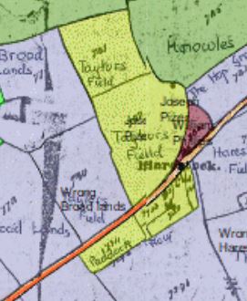
Left: Harestock 1842 occupiers - pale yellowish green of Harestock farmed by Joseph Pizer
Right: owners, Whelpley Meadow farmed by Joseph Pizer and owned by Robert Cooper in blue (rightmost field)
Twenty deeds relating to Harestock Farm in Whiteparish and property in South Marston,...
Reference: 464/56
Description:
Twenty deeds relating to Harestock Farm in Whiteparish and property in South Marston, Lullington, Avebury, Ogbourne St. George and Highworth. With
Parties: Pizer, Harris, Banning, Griffin, Russell, Robins, Ward, Stock, Bridle, Cooper, Packer, Othen, Metcalfe, Howell, Coy, Egerton, Lawes, Tarrant, Thorpe, Sanger, Nelson, Brand, Disraeli, Walker, Purkis, Crook, Nunn, Wilmot, Tilby.
Also:
Harestock Farm Sand Pit, Whiteparish.
This record is held by Wiltshire and Swindon History Centre
See contact details
Reference: F12/125/12
Description:
Harestock Farm Sand Pit, Whiteparish.
Date: 1934-1944