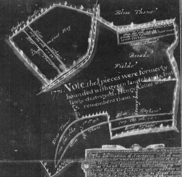
1620 map of part of Cowesfield Spilman with 1771 annotations
For larger image see here.
A Whiteparish local history page from younsmere-frustfield.org.uk
Three key maps have survived that tell us about the layout and ownership of fields and houses in Whiteparish in times past, dating from 1620, 1804 and 1842, with the earliest of these showing some changes at 1777 as well. Between them they give us glimpses of the way land use changed as modern land ownership replaced mediaeval field structures. In some parts of the parish the maps give us an understanding of still earlier layout of fields and settlements.
1620 map of part of Cowesfield Spilman with 1771 annotations
For larger image see here.
The earliest of these maps covers part of Cowesfield Spilman and dates from 1620, with additional notes from a court case in 1771. Elias Thane was Lord of the Manor of Cowesfield Spilman in 1620, when four strips were given to Corpus Christi College, Cambridge. The court case in 1771 revolved around claims that Corpus Christi had appropriated the green land channels between three of these strips and the ones adjacent to them and had extended the area covered by the fourth strip into a walk. The map shows these contested areas and the ownership of land adjacent to them.
For a detailed analysis of this map see Cowesfield Spilman 1620 Corpus Christi land.
For a detailed description and discussion, including a range of maps and another copy of the map below, see Whelpley Open Fields.
The 1804 Whelpley Enclosure Award is a map showing the land allocations made when the remaining parts of the four Whelpley commonable arable fields (Royal field, Tipple or Triple field, Elm or Ellen field and Southern field) were enclosed. It also shows ownership of adjacent land already enclosed and gives an insight into how the new land allocations gave existing landowners contiguous areas of land where possible. On the copy of the map below, the green traced boundary shows the edges of the allocation: names outside this line are the owners of adjacent areas prior to the allocation, names within it are the new allocations.
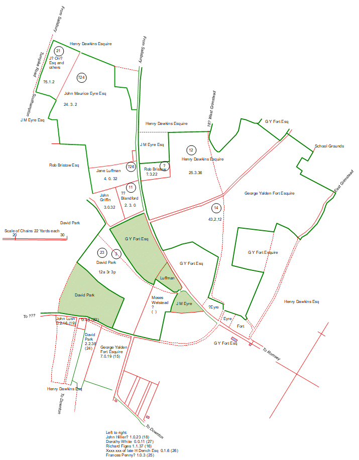
1804 Whelpley Enclosure Award with tracing overlaid
Click here or on the map above for the tracing alone
Use the northwest and southeast links below to view the original map
The open field system consisted of large areas of unfenced land owned by a manor and divided into strips, conventionally 1 chain by 1 furlong (22 by 220 yards or 20 by 200 metres), but in practice quite variable. These were individually allocated each year to the eligible people in the manor. Crops were sown in rotation, all the strips in a field growing the same crop in the same year. After harvest and during a fallow year in the rotation cycle, animals were turned onto the field to graze and fertilise the soil. Between the strips was a baulk of unploughed land and at each end of the strips a wide headland allowed for turning what was generally an ox team drawing a plough. The process of leading the team off the headland and back onto the one at other end of the field led to each strip having a gentle S shaped curve. The plough turned the soil into the strip, leading to a washboard pattern that remains visible in many manors up and down the country, but has generally been largely erased where the land has continued to be ploughed into modern times. Wikipedia Open Field System is worth looking at for a more detailed account of the open field system.
At the turn of the 19th century Whelpley still had four open fields, possibly operating a four year crop rotation. As part of a national drive towards improving farming yields, the Whelpley Enclosure Award of 1804 brought this style of farming to a close in the manor, although strips did continue rather later in the far east of the parish in the separated section of Alderstone Manor east of Cowesfield (in modern times this is thought of as part of Cowesfield). The award of 1804 divided the land into fields, each allocated to an individual. Some received large areas, while others a single strip or even half a strip in some cases, and the allocations were made in such a way that existing landowners with adjacent property received allocations contiguous with their existing land. Landowners were given a time limit during which hedges or fences had to be established around their allocation. The Lord of the Manor, as lord of the soil, received an allocation of land in compensation. In this case the title to the manor had been bought by the Eyre family, and John Maurice Eyre's substantial allocation of 24 acres was on the south side of the A27 Brickworth Road on the village side of Tipplefield Farm.
The original map can be viewed in the Wiltshire and Swindon History Centre in Chippenham, and the copy used here was made by their staff. As is often the case when copying old documents, the copy is nowhere near as clear as the original. The map below has a tracing overlaid to aid following the detail, and clicking on it or the link below takes you to a page showing just the tracing. My copy of the map can be viewed here in two parts, northwest section and southeast section. This web page displays and discusses the map that indicated the ownership of the land.
For more detail and further maps relating the 1804 allocation to the 1842 Tithe Map and modern cartography, see Whelpley Open Fields.
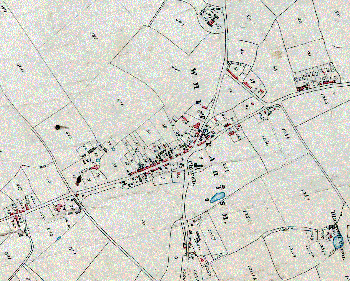
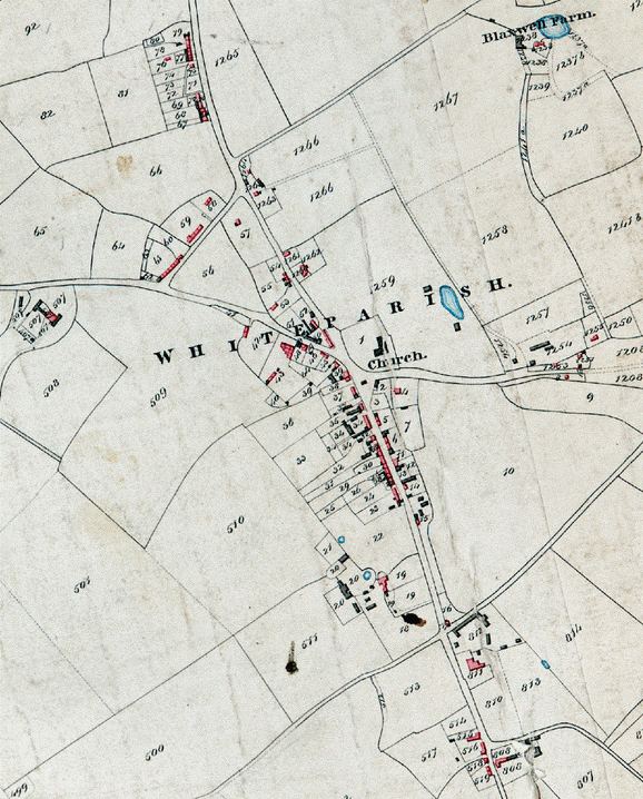
The 1842 Tithe Commutation Award map gives a comprehensive view of the parish in 1842, showing each of the 1372 separate parcels of land and listing the owner, occupier, area and use of each. As of 2024 a good quality photographic image of this map and its associated list is available online at Bristol.gov.uk. The list of apportionments is also available in a helpful database prepared by Dave Hawker at Whiteparish.co.uk.
Many pages on this website use one of several earlier copies of the 1842 Tithe Map that were based on two photocopies supplied by the Wiltshire History Centre, one to the Whiteparish Local History Society that Phoebe Merrick traced over in ink for a talk to the group in about 2000 (held by Eric Chase), and one I bought at about the same time, which is unaltered. On Phoebe's tracing, field names have been added and field boundaries overdrawn, but no distinction was made between open and enclosed field boundaries as shown on the original map. Since the accurate image of the map became available online [2024] I've been working to update images and make corrections where appropriate throughout this website. The notes below refer to the earlier copies.
I have prepared several versions of this map from these photocopies, all available via the links below, including a direct copy, Phoebe's inked version and a set of individual copies coloured to show landowners, occupiers, roads & paths, commons, land use (incomplete), manors & tithings. Phoebe's inked version is the uncoloured tracing version below, which can also be viewed on the village website at Whiteparish.co.uk. That website also provides comprehensive database access to the list of apportionments for the Tithe map and to the 1842 Census, also now available online. Thanks to Dave Hawker for permission to display his scan of Phoebe's map here and to use it as the base map for the coloured versions.
The maps on this website that still use the original copies correct an increasing number of identified copying errors of field boundaries, parcel numbers and names, although given the very large number of land parcels it is very probable that some remain and even that new mistakes may have been made. I am indebted to David Hawker for his kind permission to use his scanned map tiles of Phoebe's map as a background to the maps here while I prepare more detailed ones that faithfully reproduce the open and enclosed field boundaries on the original map and incorporate all the corrections I have found to date. In the meantime, many of these corrections are progressively appearing on the coloured maps showing landowners, occupiers, and manors and tithings viewable using the links below.
The maps can be viewed uncoloured or with colouring representing various topics of interest as follows:
This section addresses ownership of properties and property in 1842 in the centre of Whiteparish. The comparison maps below respect the 'east at the top' alignment of the Tithe Map, but first the same area is presented with north at the top for ease of recognising features . To examine individual maps and diagrams right click the map and select 'open in new tab' or 'open in new window'
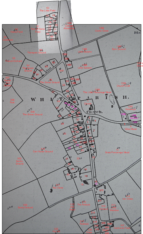
Three buildings are worth noting. Two of these are on land parcel 1259 next to the church. These may have been associated with the St Barbe Manor House that occupied this site and was demolished in 1812. The well under the Memorial Hall car park is further north. The third building is unlabelled in the triangle between Common Road and The Street in front of the church. This also featured on the 1773 Andrews and Drury map and was perhaps a well house.
The centre of Whiteparish village on the 1842 Tithe Map
The orientation here puts north at the top rather than at the left as on the original map
Right click image and select 'open in new tab' or 'open in new window' for a larger image
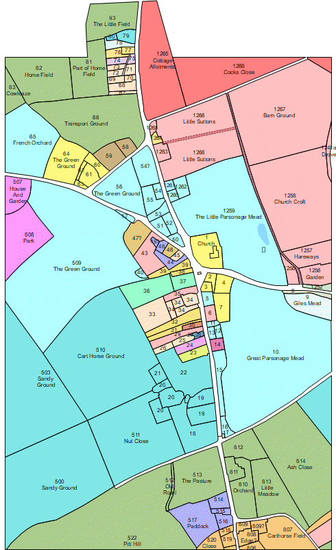
The 1842 Tithe Map and tracings showing the land parcels in the centre of the village
Left to right: original map, tracing over original map [recheck boundaries and numbers], tracing alone, landowners
See this full copy of the Tithe map for colours used for each landowner
Key to manors: pale pink and green at the top: Blaxwell; dark pink at the top: Cowesfield Esturmy; pale blue: Alderstone; dark blue and green at bottom: Whelpley
Right click a map and select "open in new tab" or "open in new window" to view a larger copy
Detailed discussion of all aspects of this map can be found widely spread across this website on the pages describing the manors, farms, estates and settlements in the parish. Use the contents list to the left or full alphabetic index to reach pages of interest.
The links here give access to fully detailed images - in each case if you prefer a smaller image scaled to your screen then open the link in a new window or tab by right clicking and selecting as appropriate.
Click here for a fully detailed image of the 1620 map of part of Cowesfield Spilman used in a court case in 1771. Elias Thane was lord of the manor at the time.
Click here for a fully detailed image of the Whelpley Enclosure Award Map 1804, or open in a new window for a scaled version of the map.
Click here for the Whelpley Enclosure Award Map 1804 overlaid on the 1840 Tithe Map to show how fields had changed in the intervening 36 years. A more up to date version of this map is now available here (scroll down that map to row 3 to view the map).
A photographic image of the full Tithe Map is now available online at Bristol.gov.uk, allowing you to explore the map more fully and in greater detail. To help get you started if you're using this for the first time, you might find it helpful to click the magnifying glass at top left and select Whiteparish, and click the 'Information layers' tab on the right and change one of the Basemaps to '1840s Wiltshire Tithes' . There are other maps there to explore and the rest of Wiltshire too.